Cushion > Europe > France > Canton > Landes
Cushion : Childrens Political Europe Map


![]()
Home Decor from Map Marketing
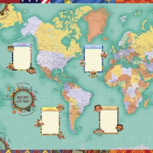
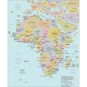
Childrens Political Europe Map
A Political map of Europe designed for school children. Based on the Lambert Conformal Conic projection, the Europe map covers the whole of the continent from northern Africa to Norwayaes North Cape and from the Azores to the Caspian Sea. The map clearly marks each country in a different colour and shows all capitals and major cities in five different population bands. It also includes a handy map insert detailing current and potential future EU member countries. The key features a useful graph detailing the top five European countries by population and by land mass
Media ID 19950521
© Map Marketing Ltd
Cushion
Refresh your home decor with a beautiful full photo 16"x16" (40x40cm) cushion, complete with cushion pad insert. Printed on both sides and made from 100% polyester with a zipper on the bottom back edge of the cushion cover. Care Instructions: Warm machine wash, do not bleach, do not tumble dry. Warm iron inside out. Do not dry clean.
Accessorise your space with decorative, soft cushions
Estimated Product Size is 40cm x 40cm (15.7" x 15.7")
These are individually made so all sizes are approximate
Artwork printed orientated as per the preview above, with landscape (horizontal) or portrait (vertical) orientation to match the source image.
FEATURES IN THESE COLLECTIONS
> Europe
> France
> Canton
> Landes
> Maps and Charts
> Related Images
MADE IN AUSTRALIA
Safe Shipping with 30 Day Money Back Guarantee
FREE PERSONALISATION*
We are proud to offer a range of customisation features including Personalised Captions, Color Filters and Picture Zoom Tools
SECURE PAYMENTS
We happily accept a wide range of payment options so you can pay for the things you need in the way that is most convenient for you
* Options may vary by product and licensing agreement. Zoomed Pictures can be adjusted in the Cart.