Cushion > Maps and Charts > Americas
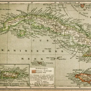
Cushion : Lorgues / Caribbean Map


![]()
Home Decor from Mary Evans Picture Library
Lorgues / Caribbean Map
A map showing the travels of Columbus in the Caribbean
Mary Evans Picture Library makes available wonderful images created for people to enjoy over the centuries
Media ID 605451
© Mary Evans Picture Library 2015 - https://copyrighthub.org/s0/hub1/creation/maryevans/MaryEvansPictureID/10053035
1492 1502 Caribbean Columbus Lorgues Travels
Cushion
Refresh your home decor with a beautiful full photo 16"x16" (40x40cm) cushion, complete with cushion pad insert. Printed on both sides and made from 100% polyester with a zipper on the bottom back edge of the cushion cover. Care Instructions: Warm machine wash, do not bleach, do not tumble dry. Warm iron inside out. Do not dry clean.
Accessorise your space with decorative, soft cushions
Estimated Product Size is 40cm x 40cm (15.7" x 15.7")
These are individually made so all sizes are approximate
Artwork printed orientated as per the preview above, with landscape (horizontal) or portrait (vertical) orientation to match the source image.
FEATURES IN THESE COLLECTIONS
> Maps and Charts
> Early Maps
> Maps and Charts
> Related Images
EDITORS COMMENTS
This print from Mary Evans Picture Library showcases a historical map titled "Lorgues / Caribbean Map," highlighting the travels of Christopher Columbus in the Caribbean between 1492 and 1502. The intricately detailed map offers a glimpse into one of the most significant events in American history, as Columbus embarked on his groundbreaking voyages that would forever change the course of exploration and discovery.
The map not only serves as a geographical representation of Columbus's travels but also provides valuable insights into the cultural and historical significance of his expeditions. From the lush landscapes to the intricate coastlines, every detail on this map tells a story of adventure, perseverance, and discovery.
As we gaze upon this remarkable piece of history, we are transported back in time to an era filled with excitement and uncertainty. We can almost envision Columbus setting sail across uncharted waters, driven by an insatiable curiosity and a relentless desire to explore new horizons.
Whether you're a history enthusiast or simply appreciate beautiful works of art, this print is sure to captivate your imagination and inspire you to delve deeper into the fascinating world of Christopher Columbus's travels in the Caribbean. It is truly a treasure trove of historical knowledge waiting to be explored.
MADE IN AUSTRALIA
Safe Shipping with 30 Day Money Back Guarantee
FREE PERSONALISATION*
We are proud to offer a range of customisation features including Personalised Captions, Color Filters and Picture Zoom Tools
SECURE PAYMENTS
We happily accept a wide range of payment options so you can pay for the things you need in the way that is most convenient for you
* Options may vary by product and licensing agreement. Zoomed Pictures can be adjusted in the Cart.