Cushion > Europe > United Kingdom > England > Sussex > Broadwater
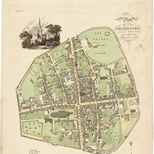
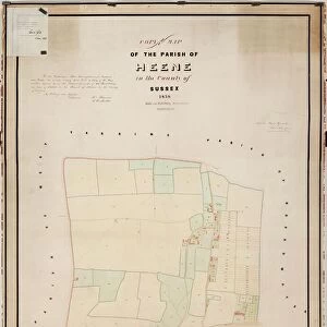
Cushion : Street Plan of Worthing c1830


![]()
Home Decor from West Sussex County Council
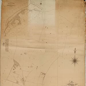
Street Plan of Worthing c1830
Shows Warwick House and gardens, Wortley House, Marine Library, Sea House Hotel, and New Town (built c1820s on what is now Clifton Road). Interestingly, Union Place is called Union Street, which there is no reference to it ever being called. It is not as detailed as the 1826 / 1832 Wallis plans, but is charmingly coloured in watercolour. The Worthing Map Story does not make any mention of this plan, but it does refer to the early street plans as not always being perfectly accurate, as they were usually copied from each other. This does make dating the plan an inexact science, as the absence of a building does not mean that it was not there at the time. It appears to be earlier than the Broadwater Tithe Map of 1848, and is later than the early 1820s, as it shows Ambrose Place. The northern section of Chapel Road (Teville Road to Winton Place - Bo-Peep Lane at time, and unmarked) is called North Street, a name it lost in 1836. The western end of Montague Street is described as Cross Lane, a name it retained until c1820 (it is Montague Street on the 1826 Wallis plan). The lack of detail on this map compared to the 1814 and 1826 plans does not necessarily mean that it is earlier than either of these, as there are buildings on this plan that date it to the late 1820s, early 1830s.
Printed Maps Collection
West Sussex Record Office Ref No: PM 929
West Sussex County Council Record Office contains a fascinating history of the county of West Sussex, England
Media ID 7657098
© West Sussex County Council - All Rights Reserved
Cushion
Refresh your home decor with a beautiful full photo 16"x16" (40x40cm) cushion, complete with cushion pad insert. Printed on both sides and made from 100% polyester with a zipper on the bottom back edge of the cushion cover. Care Instructions: Warm machine wash, do not bleach, do not tumble dry. Warm iron inside out. Do not dry clean.
Accessorise your space with decorative, soft cushions
Estimated Product Size is 40cm x 40cm (15.7" x 15.7")
These are individually made so all sizes are approximate
Artwork printed orientated as per the preview above, with landscape (horizontal) or portrait (vertical) orientation to match the source image.
FEATURES IN THESE COLLECTIONS
> Animals
> Mammals
> Muridae
> Western Mouse
> Arts
> Photorealistic artworks
> Detailed art pieces
> Masterful detailing in art
> Europe
> United Kingdom
> England
> Sussex
> Broadwater
> Europe
> United Kingdom
> England
> Sussex
> New Town
> Europe
> United Kingdom
> England
> Sussex
> North End
> Europe
> United Kingdom
> England
> Sussex
> Related Images
> Europe
> United Kingdom
> England
> Sussex
> Street End
> Europe
> United Kingdom
> England
> Sussex
> West Worthing
> Europe
> United Kingdom
> England
> Sussex
> Worth
> West Sussex County Council
> West Sussex Record Office
> Printed Maps
EDITORS COMMENTS
This charmingly colored watercolor print showcases the Street Plan of Worthing circa 1830. The map highlights various landmarks and buildings, including Warwick House and gardens, Wortley House, Marine Library, Sea House Hotel, and New Town (which was constructed in the 1820s on what is now Clifton Road). Interestingly, Union Place is labeled as Union Street on this plan, despite no historical reference to it ever being called so. Although not as detailed as the 1826/1832 Wallis plans, this print offers a unique glimpse into Worthing's past. The Worthing Map Story does not mention this particular plan but acknowledges that early street plans were often imperfectly accurate due to their replication from one another. Consequently, dating this map precisely becomes an inexact science since the absence of a building does not necessarily indicate its nonexistence at that time. Based on its features and details depicted, it appears to predate the Broadwater Tithe Map of 1848 while also postdating the early 1820s with references to Ambrose Place. Notably, Chapel Road's northern section is referred to as North Street before losing that name in 1836. Additionally, Montague Street's western end is described as Cross Lane until approximately 1820 when it became known by its current name. Despite lacking some detail compared to earlier plans like those from 1814 and 1826, this map still includes buildings that date it back to the late-1820s or early-1830s. This intriguing piece can be found within West Sussex Record Office's Printed Maps Collection under Ref No: PM929 (not for commercial use).
MADE IN AUSTRALIA
Safe Shipping with 30 Day Money Back Guarantee
FREE PERSONALISATION*
We are proud to offer a range of customisation features including Personalised Captions, Color Filters and Picture Zoom Tools
SECURE PAYMENTS
We happily accept a wide range of payment options so you can pay for the things you need in the way that is most convenient for you
* Options may vary by product and licensing agreement. Zoomed Pictures can be adjusted in the Cart.


![Royal Engineers bomb disposal team at work, [Mar 1941]](/sq/479/royal-engineers-bomb-disposal-team-work-8359434.jpg.webp)