Home > Arts > Artists > C > Cambodian Cambodian
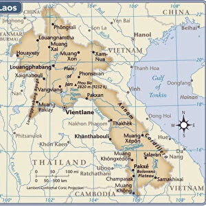
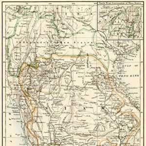
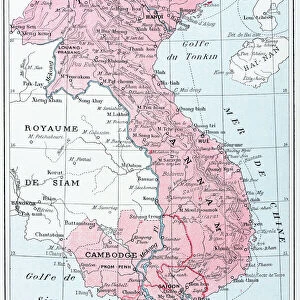
Map of India and Southern Asia dating from 1792

![]()
Wall Art and Photo Gifts from Design Pics
Map of India and Southern Asia dating from 1792
Design Pics offers Distinctively Different Imagery representing over 1,500 contributors
Media ID 24903223
© Ken Welsh / Design Pics
18th Century Cambodia Ceylon Countries Geographical Geography India Laos Thailand Tibet Bay Of Bengal Southern Asia
FEATURES IN THESE COLLECTIONS
> Arts
> Artists
> C
> Cambodian Cambodian
> Asia
> Cambodia
> Related Images
> Asia
> India
> Related Images
> Asia
> Laos
> Related Images
> Asia
> Thailand
> Related Images
EDITORS COMMENTS
This print showcases a remarkable piece of history - a Map of India and Southern Asia dating all the way back to 1792. With its intricate details and exquisite craftsmanship, this illustration takes us on a journey through time, offering glimpses into the geographical landscape and political boundaries of that era. The map reveals an expansive region, encompassing present-day countries such as India, Thailand, Tibet, Cambodia, Laos, and Ceylon (now Sri Lanka). It provides valuable insights into the historical context of these nations during the 18th century. The Bay of Bengal stands out prominently in this depiction as it connects various coastal regions. Examining this archival treasure allows us to appreciate the immense efforts put forth by cartographers like Welsh Ken who meticulously documented these lands centuries ago. Every contour line represents countless hours spent surveying and mapping uncharted territories. As we delve deeper into this visual masterpiece, we are transported to an era when exploration was at its peak. This map serves as a testament to human curiosity and our relentless pursuit of knowledge about our world. Whether you are a history enthusiast or simply fascinated by geography's evolution over time, this vintage map is sure to captivate your imagination. Displayed proudly on any wall or surface in your home or office space; it will undoubtedly spark conversations about ancient civilizations and their interconnectedness across Southern Asia.
MADE IN AUSTRALIA
Safe Shipping with 30 Day Money Back Guarantee
FREE PERSONALISATION*
We are proud to offer a range of customisation features including Personalised Captions, Color Filters and Picture Zoom Tools
SECURE PAYMENTS
We happily accept a wide range of payment options so you can pay for the things you need in the way that is most convenient for you
* Options may vary by product and licensing agreement. Zoomed Pictures can be adjusted in the Cart.