
Maps Collection
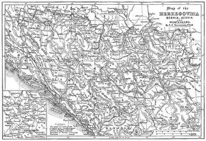
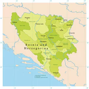
Maps of Bosnia and Herzegovina Europe are a representation of the country's geography
Choose a picture from our Maps Collection for your Wall Art and Photo Gifts
40 items


All Professionally Made to Order for Quick Shipping
-
Maps Collection
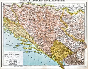
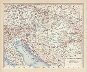
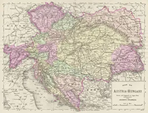
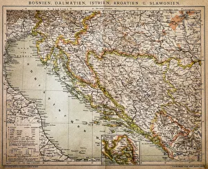
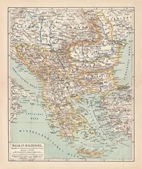
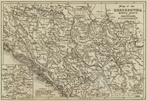
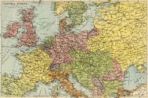
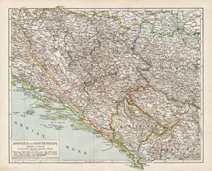
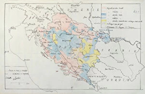
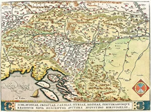
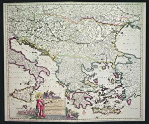
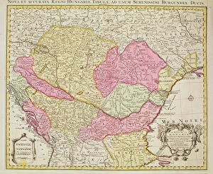
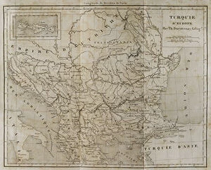
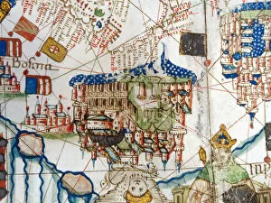
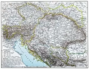
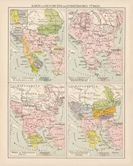
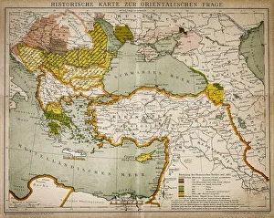
Maps of Bosnia and Herzegovina Europe are a representation of the country's geography. The maps show the country's two autonomous regions, the Federation of Bosnia and Herzegovina and Republika Srpska, as well as its capital city, Sarajevo. They also depict its major rivers, lakes, mountains and other geographical features. Additionally, they display important cities such as Mostar and Banja Luka. The maps provide an overview of the region's political boundaries with neighbouring countries such as Croatia and Serbia. Furthermore, they highlight important transportation routes including highways, railways and airports that connect Bosnia to other parts of Europe. Overall these maps offer a comprehensive view of this small but diverse nation in Eastern Europe.
+
Our beautiful pictures are available as Framed Prints, Photos, Wall Art and Photo Gifts
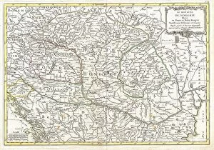
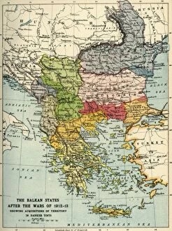
The Maps of Bosnia and Herzegovina Europe collection from Media Storehouse is a stunning selection of wall art and framed prints that showcase the intricate cartography of this beautiful region. Our collection features an array of maps, ranging from historical depictions to modern-day renderings, each capturing the unique topography and geography of Bosnia and Herzegovina. From detailed street maps to panoramic views, these pieces offer a fascinating glimpse into the country's rich history, culture, and natural beauty. Whether you're looking for a striking centerpiece for your living room or office space or simply want to add some visual interest to your walls, our collection has something for everyone. With high-quality printing techniques and premium materials used in every piece, these maps are sure to impress even the most discerning art lovers. So why not explore the Maps of Bosnia and Herzegovina Europe collection today?
+
What are Maps of Bosnia and Herzegovina Europe art prints?
Maps of Bosnia and Herzegovina Europe art prints are high-quality reproductions of maps that depict the geography, topography, and political boundaries of Bosnia and Herzegovina. These prints are designed to be visually appealing while also providing accurate information about the region. These art prints can be used for a variety of purposes, including educational displays in classrooms or museums, decorative pieces in homes or offices, or as gifts for those with an interest in geography or history. They come in a range of sizes and styles to suit different preferences. We offer a wide selection of Maps of Bosnia and Herzegovina Europe art prints from various sources. Each print is carefully produced using state-of-the-art printing technology to ensure that it accurately captures the details and colors of the original map. With their high quality and attractive designs, these art prints are sure to enhance any space they are displayed in.
+
What Maps of Bosnia and Herzegovina Europe art prints can I buy from Media Storehouse?
We offer a wide range of Maps of Bosnia and Herzegovina Europe art prints that you can choose from. These maps are available in various sizes, styles, and designs to suit your preferences. You can find antique maps that showcase the historical development of Bosnia and Herzegovina over time or modern-day maps that highlight its current political boundaries. Additionally, Media Storehouse also provides topographical maps that show the physical features of the country such as mountains, rivers, lakes, and forests. These detailed maps are perfect for hikers or outdoor enthusiasts who want to explore Bosnia and Herzegovina's natural beauty. Moreover, we have city street maps that display major roads, landmarks, and tourist attractions in cities like Sarajevo or Mostar. These city street maps are ideal for travelers who want to navigate their way around these cities with ease. Media Storehouse has an extensive collection of Maps of Bosnia and Herzegovina Europe art prints that cater to different interests and purposes.
+
How do I buy Maps of Bosnia and Herzegovina Europe art prints?
To purchase Maps of Bosnia and Herzegovina Europe art prints from Media Storehouse, you can browse our extensive collection of maps on their website. Once you have found the map that you would like to purchase, simply add it to your cart and proceed to checkout. At this point, you will be prompted to enter your shipping and payment information. We offer a variety of sizes for their art prints, so make sure to select the size that best fits your needs. We also offer different framing options if you choose to have your print framed. If you have any questions or concerns about purchasing Maps of Bosnia and Herzegovina Europe art prints from Media Storehouse, they provide customer support through email or phone. Their team is happy to assist with any inquiries regarding product availability or order status.
+
How much do Maps of Bosnia and Herzegovina Europe art prints cost?
We offer a wide range of Maps of Bosnia and Herzegovina Europe art prints that vary in price depending on the size and type of print you choose. Our collection includes vintage maps, contemporary designs, and satellite imagery that capture the beauty and diversity of this region. Whether you're looking for a small poster or a large canvas print, we have something to suit every budget. Our high-quality art prints are produced using state-of-the-art printing technology to ensure vibrant colors and sharp details. We use only premium materials such as archival paper and fade-resistant inks to guarantee long-lasting durability. We pride ourselves on offering affordable prices without compromising on quality. Our Maps of Bosnia and Herzegovina Europe art prints are an excellent way to add style and sophistication to your home or office decor while celebrating the rich history and culture of this fascinating country.
+
How will my Maps of Bosnia and Herzegovina Europe art prints be delivered to me?
We take great care in ensuring that your Maps of Bosnia and Herzegovina Europe art prints are delivered to you safely and securely. We use high-quality packaging materials to protect your print during transit, including sturdy cardboard tubes for rolled prints and flat cardboard envelopes for smaller sizes. We work with trusted shipping partners who offer reliable delivery services worldwide. Depending on your location, we may use a range of different carriers to ensure the fastest possible delivery times. Once your order has been dispatched from our warehouse, you will receive an email confirmation containing tracking information so that you can monitor the progress of your shipment. We pride ourselves on providing exceptional customer service and ensuring that every order is delivered promptly and in perfect condition. If you have any questions or concerns about the delivery of your Maps of Bosnia and Herzegovina Europe art prints, please don't hesitate to contact us directly.