Home > Arts > Artists > I > Irish School Irish School
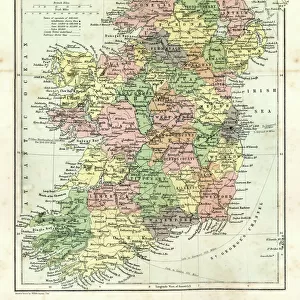
OS map, 1922: Flintshire, Shropshire, Staffordshire, Leicestershire (colour litho)
")
![]()
Wall Art and Photo Gifts from Fine Art Finder
OS map, 1922: Flintshire, Shropshire, Staffordshire, Leicestershire (colour litho)
8645559 OS map, 1922: Flintshire, Shropshire, Staffordshire, Leicestershire (colour litho) by English School, (20th century); Private Collection; (add.info.: Flintshire, Shropshire, Staffordshire, Leicestershire. Illustration for the Ordnance Survey Map of England and Wales, Quarter Inch to the Mile (1922).); © Look and Learn
Media ID 38128124
© © Look and Learn / Bridgeman Images
Leicestershire Shropshire Staffordshire Stereoscopic Card Stereoscopy
FEATURES IN THESE COLLECTIONS
> Arts
> Artists
> I
> Irish School Irish School
> Europe
> Republic of Ireland
> Maps
> Europe
> United Kingdom
> England
> Leicestershire
> Related Images
> Europe
> United Kingdom
> England
> Maps
> Europe
> United Kingdom
> England
> Shropshire
> Related Images
> Europe
> United Kingdom
> England
> Staffordshire
> Related Images
> Europe
> United Kingdom
> Maps
> Europe
> United Kingdom
> Northern Ireland
> Maps
> Europe
> United Kingdom
> Northern Ireland
> Posters
> Europe
> United Kingdom
> Northern Ireland
> Related Images
> Fine Art Finder
> Artists
> English School
EDITORS COMMENTS
This stunning print of an OS map from 1922 showcases the intricate details of Flintshire, Shropshire, Staffordshire, and Leicestershire in vibrant color. The English School's meticulous work on this quarter-inch to the mile map for the Ordnance Survey Map of England and Wales is truly a sight to behold.
As you gaze upon this piece, you are transported back to the early twentieth century when maps were essential tools for navigation and exploration. The fine lines and carefully labeled landmarks offer a glimpse into the past, allowing us to appreciate how these counties have evolved over time.
The rich history of England is captured within this map, highlighting its diverse landscapes and cultural heritage. From rolling hills to bustling towns, each area depicted tells a unique story that has shaped the fabric of British society.
Whether you are a cartography enthusiast or simply admire historical artifacts, this print is sure to captivate your imagination. It serves as a reminder of the importance of preserving our past while also inspiring future generations to continue exploring and mapping out new territories.
MADE IN AUSTRALIA
Safe Shipping with 30 Day Money Back Guarantee
FREE PERSONALISATION*
We are proud to offer a range of customisation features including Personalised Captions, Color Filters and Picture Zoom Tools
SECURE PAYMENTS
We happily accept a wide range of payment options so you can pay for the things you need in the way that is most convenient for you
* Options may vary by product and licensing agreement. Zoomed Pictures can be adjusted in the Cart.