Home > Arts > Artists > H > Jodocus Hondius
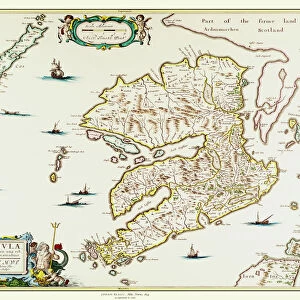
Carte de la Pologne, 17eme siecle - Nova Poloniae delineation - (Map of Poland) - Oeuvre de Jocodus Hondius l Ancien (Josse de Hond) (1563-1612), gravure (33, 7x47, 9 cm), vers 1629-1630 - Collection privee
 - Oeuvre de Jocodus Hondius l Ancien (Josse de Hond) (1563-1612), gravure (33, 7x47, 9 cm), vers 1629-1630 - Collection privee")
![]()
Wall Art and Photo Gifts from Fine Art Finder
Carte de la Pologne, 17eme siecle - Nova Poloniae delineation - (Map of Poland) - Oeuvre de Jocodus Hondius l Ancien (Josse de Hond) (1563-1612), gravure (33, 7x47, 9 cm), vers 1629-1630 - Collection privee
FIA5391203 Carte de la Pologne, 17eme siecle - Nova Poloniae delineation - (Map of Poland) - Oeuvre de Jocodus Hondius l Ancien (Josse de Hond) (1563-1612), gravure (33, 7x47, 9 cm), vers 1629-1630 - Collection privee by Hondius, Jodocus (1567-1611); Private Collection; Photo © Fine Art Images
Media ID 24912230
© Fine Art Images / Bridgeman Images
Atlas Book Of Maps Poland Polish Pole Netherlands Holland Dutch
FEATURES IN THESE COLLECTIONS
> Arts
> Artists
> H
> Jodocus Hondius
> Europe
> Netherlands
> Maps
> Europe
> Netherlands
> Posters
> Europe
> Netherlands
> Related Images
> Europe
> Poland
> Related Images
> Fine Art Finder
> Artists
> Georg Friedrich Schmidt
> Fine Art Finder
> Artists
> Jodocus Hondius
> Maps and Charts
> Netherlands
> Maps and Charts
> Related Images
EDITORS COMMENTS
This print showcases a remarkable piece of cartographic history - "Carte de la Pologne, 17eme siecle" by Jocodus Hondius l Ancien. Created in the late 16th century, this intricately detailed map of Poland provides a fascinating glimpse into the country's geography during that time. Measuring at approximately 33.7x47.9 cm, this engraving is a testament to Hondius' skill and precision as a cartographer. The map features Nova Poloniae delineation, offering an accurate representation of Poland's cities, rivers, and topography. Hondius was renowned for his expertise in creating maps and atlases during the Dutch Golden Age. His work not only served practical purposes but also became highly sought after as decorative pieces due to their artistic value. This particular print dates back to around 1629-1630 and belongs to a private collection. Its preservation allows us to appreciate the craftsmanship of Hondius even centuries later. The image transports us back in time, allowing us to explore Poland through the eyes of an accomplished cartographer from the past. It serves as a reminder of how maps have played an essential role in understanding our world throughout history. Whether you are fascinated by geography or simply appreciate fine artistry, this print offers both historical significance and aesthetic pleasure – truly capturing the essence of Jocodus Hondius l Ancien's legacy.
MADE IN AUSTRALIA
Safe Shipping with 30 Day Money Back Guarantee
FREE PERSONALISATION*
We are proud to offer a range of customisation features including Personalised Captions, Color Filters and Picture Zoom Tools
SECURE PAYMENTS
We happily accept a wide range of payment options so you can pay for the things you need in the way that is most convenient for you
* Options may vary by product and licensing agreement. Zoomed Pictures can be adjusted in the Cart.