Home > Europe > France > Paris > Sights > Louvre
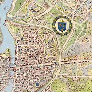
Map of Paris c. 1540, known as the Plan de la Tapisserie, made as a tapestry c

![]()
Wall Art and Photo Gifts from Fine Art Finder
Map of Paris c. 1540, known as the Plan de la Tapisserie, made as a tapestry c
CHT163104 Map of Paris c.1540, known as the Plan de la Tapisserie, made as a tapestry c.1571, 1818 (colour engraving) by Naudet, Caroline (1775-1839); Bibliotheque Historique de la Ville de Paris, Paris, France; (add.info.: Together with the map of Sebastian MAonster and the Plan de la Gouache, this is one of the oldest plans of Paris. The original map was woven as a tapestry c.1571 for Cardinal Charles de Bourbon (1523-90). In 1571 he was made Lieutenant-General of Paris and Ile de France and his heraldic arms are displayed here. Later the tapestry passed to the Guise family and was kept at the HA'tel de Clisson. The tapestry disappeared during the French Revolution but a copy had been made for the French antiquary, FranAzois de GaigniAres (1642-1715) ecuyer (equerry) to Louis Joseph, duke of Guise (1650-71). This map shows Paris after the beginning of the dismantling in 1533 (on the orders of FranAzois Premier) of the inner Right Bank Enceinte (city wall) of Philippe II Auguste but the sections near the Louvre and in the 3rd and 4th Arrondissements are clearly visible on the map.); eArchives Charmet; French, out of copyright
Media ID 23364616
© Archives Charmet / Bridgeman Images
16th Armoiries Bourbon Capital City Carte Earliest Heraldry Ile De La Cite Oldest Rive Droite Rive Gauche River Seine Street Map
FEATURES IN THESE COLLECTIONS
> Arts
> Artists
> Related Images
> Arts
> Landscape paintings
> Waterfall and river artworks
> River artworks
> Arts
> Portraits
> Pop art gallery
> Street art portraits
> Europe
> France
> Heritage Sites
> Paris, Banks of the Seine
> Europe
> France
> Paris
> Maps
> Europe
> France
> Paris
> Museums
> The Louvre
> Europe
> France
> Paris
> River Seine
> Europe
> France
> Paris
> Sights
> Louvre
> Fine Art Finder
> Artists
> Caroline Naudet
> Fine Art Finder
> Artists
> Italian School
> Fine Art Finder
> Maps (celestial & Terrestrial)
> Maps and Charts
> Early Maps
EDITORS COMMENTS
This print showcases the "Map of Paris c. 1540, known as the Plan de la Tapisserie". Created as a tapestry in around 1571, this map offers a fascinating glimpse into the historical layout of Paris during that time period. The original tapestry was commissioned for Cardinal Charles de Bourbon and featured his heraldic arms prominently displayed. Over the years, this remarkable piece passed through various hands, eventually finding its place at the HA'tel de Clisson under the ownership of the Guise family. Unfortunately, during the turbulence of the French Revolution, the tapestry disappeared. However, a copy had been made for FranAzois de GaigniAres, an esteemed French antiquary who served as equerry to Louis Joseph, duke of Guise. The map itself depicts Paris after significant changes were made to its city walls in 1533 on orders from FranAzois Premier. Notably visible are sections near iconic landmarks such as Louvre and within today's 3rd and 4th Arrondissements. With its intricate details and historical significance, this image provides viewers with a unique opportunity to explore one of Paris' oldest plans. Preserved by eArchives Charmet and brought to life by Bridgeman Images' expertise in fine art reproduction, this print allows us to appreciate both the artistic beauty and rich history encapsulated within this ancient map.
MADE IN AUSTRALIA
Safe Shipping with 30 Day Money Back Guarantee
FREE PERSONALISATION*
We are proud to offer a range of customisation features including Personalised Captions, Color Filters and Picture Zoom Tools
SECURE PAYMENTS
We happily accept a wide range of payment options so you can pay for the things you need in the way that is most convenient for you
* Options may vary by product and licensing agreement. Zoomed Pictures can be adjusted in the Cart.