Home > Historic > Ancient civilizations > Roman Empire > Ancient roman cities
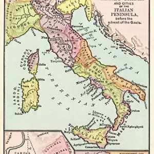
Geographic map of the territories of Italy (upper), the Roman hills (lower left) and the surroundings of the city of Rome during the Roman Empire. Lithograph of the 19th century
, the Roman hills (lower left) and the surroundings of the city of Rome during the Roman Empire. Lithograph of the 19th century")
![]()
Wall Art and Photo Gifts from Fine Art Finder
Geographic map of the territories of Italy (upper), the Roman hills (lower left) and the surroundings of the city of Rome during the Roman Empire. Lithograph of the 19th century
NWI4863026 Geographic map of the territories of Italy (upper), the Roman hills (lower left) and the surroundings of the city of Rome during the Roman Empire. Lithograph of the 19th century.; (add.info.: Geographic map of the territories of Italy (upper), the Roman hills (lower left) and the surroundings of the city of Rome during the Roman Empire. Lithograph of the 19th century.); Photo © North Wind Pictures
Media ID 38418094
© © North Wind Pictures / Bridgeman Images
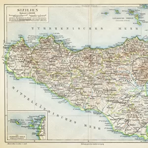
Sicilian Sicily Antique Rome Geographical Map
FEATURES IN THESE COLLECTIONS
> Europe
> Italy
> Sicily
> Related Images
> Fine Art Finder
> Artists
> José del Pozo
> Historic
> Ancient civilizations
> Roman Empire
> Ancient roman cities
> Historic
> Ancient civilizations
> Roman Empire
> Ancient Rome
> Historic
> Ancient civilizations
> Roman Empire
> Roman art
> Maps and Charts
> Italy
EDITORS COMMENTS
This stunning lithograph from the 19th century showcases a detailed geographic map of Italy, the Roman hills, and the surrounding areas of Rome during the height of the Roman Empire. The intricate details and vibrant colors bring to life the ancient territories and landmarks that once defined this historic region.
As you study this print, you can imagine yourself walking through the bustling streets of Rome, exploring its majestic architecture and rich history. The map provides a glimpse into the past, allowing us to visualize how these lands were divided and connected during one of the greatest empires in history.
The Italian peninsula is depicted with precision, highlighting its diverse landscapes and cities. From Sicily in the south to the Roman hills in the north, every corner of Italy is captured on this map with accuracy and artistry.
Whether you are a history enthusiast or simply appreciate fine art, this lithograph is sure to captivate your imagination. It serves as a reminder of Italy's enduring legacy as a cultural powerhouse and invites us to explore its ancient roots through visual storytelling.
MADE IN AUSTRALIA
Safe Shipping with 30 Day Money Back Guarantee
FREE PERSONALISATION*
We are proud to offer a range of customisation features including Personalised Captions, Color Filters and Picture Zoom Tools
SECURE PAYMENTS
We happily accept a wide range of payment options so you can pay for the things you need in the way that is most convenient for you
* Options may vary by product and licensing agreement. Zoomed Pictures can be adjusted in the Cart.