Home > Arts > Artists > K > Johannes van Keulen
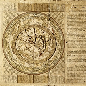
A chart bound in Van Keulen's 'Great and Newly Enlarged Sea Atlas', 1682 (print)
")
![]()
Wall Art and Photo Gifts from Fine Art Finder
A chart bound in Van Keulen's 'Great and Newly Enlarged Sea Atlas', 1682 (print)
7340728 A chart bound in Van Keulen's 'Great and Newly Enlarged Sea Atlas', 1682 (print) by Keulen, Johannes van (1654-1715); 5.3x6.2 cm; National Maritime Museum, London, UK; (add.info.: Creator: Van Keulen
A chart bound in Van Keulen's 'Great and Newly Enlarged Sea Atlas'); © National Maritime Museum, Greenwich, London
Media ID 38177740
© © National Maritime Museum, Greenwich, London / Bridgeman Images
Asiae Australians Cartography South East Asia
FEATURES IN THESE COLLECTIONS
> Arts
> Artists
> K
> Johannes van Keulen
> Europe
> United Kingdom
> England
> London
> Boroughs
> Greenwich
> Europe
> United Kingdom
> England
> London
> Museums
> Greenwich Heritage Centre
> Europe
> United Kingdom
> England
> London
> Museums
> National Maritime Museum
> Europe
> United Kingdom
> England
> London
> Towns
> Greenwich
> Europe
> United Kingdom
> Heritage Sites
> Maritime Greenwich
> Europe
> United Kingdom
> Maps
> Fine Art Finder
> Artists
> Johannes van Keulen
> Fine Art Finder
> Artists
> Sydney Hall
> Maps and Charts
> Early Maps
EDITORS COMMENTS
This stunning print captures a chart bound in Van Keulen's 'Great and Newly Enlarged Sea Atlas' from 1682. The intricate details of this historical map, created by Johannes van Keulen, showcase the artistry and precision of cartography in the 17th century.
Measuring at just 5.3x6.2 cm, this small but mighty chart holds a wealth of information about Asia, Australia, and Oceania. The vibrant colors used to highlight different regions make this piece visually captivating and engaging for viewers.
As you gaze upon this print, you can't help but marvel at the craftsmanship that went into creating such a detailed map without the modern technology we have today. Every line and symbol on the chart tells a story of exploration and discovery during a time when much of these lands were still uncharted territory.
The National Maritime Museum in London is home to this valuable piece of history, preserving it for future generations to admire and learn from. It serves as a reminder of how far we've come in terms of navigation and mapping techniques while also honoring the legacy of early cartographers like Johannes van Keulen.
Overall, this print is not just an image on paper; it's a window into the past that allows us to appreciate both the beauty and complexity of historical maps like never before.
MADE IN AUSTRALIA
Safe Shipping with 30 Day Money Back Guarantee
FREE PERSONALISATION*
We are proud to offer a range of customisation features including Personalised Captions, Color Filters and Picture Zoom Tools
SECURE PAYMENTS
We happily accept a wide range of payment options so you can pay for the things you need in the way that is most convenient for you
* Options may vary by product and licensing agreement. Zoomed Pictures can be adjusted in the Cart.