Home > Arts > Literature > Magazines
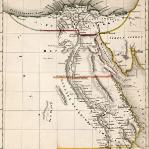
Plan of the town and fortifications of Montral or Villa Marie in Canada, 1759 (paper)
")
![]()
Wall Art and Photo Gifts from Fine Art Finder
Plan of the town and fortifications of Montral or Villa Marie in Canada, 1759 (paper)
7340764 Plan of the town and fortifications of Montral or Villa Marie in Canada, 1759 (paper) by Unknown artist, (18th century); 40.5x27 cm; National Maritime Museum, London, UK; (add.info.: Creator: Universal Magazine
An ungraduated plan with a key. Published in MS 'Universal Magazine' November 1759.); © National Maritime Museum, Greenwich, London
Media ID 38177640
© © National Maritime Museum, Greenwich, London / Bridgeman Images
FEATURES IN THESE COLLECTIONS
> Arts
> Literature
> Magazines
> Europe
> United Kingdom
> England
> London
> Boroughs
> Greenwich
> Europe
> United Kingdom
> England
> London
> Museums
> Greenwich Heritage Centre
> Europe
> United Kingdom
> England
> London
> Museums
> National Maritime Museum
> Europe
> United Kingdom
> England
> London
> Towns
> Greenwich
> Europe
> United Kingdom
> Heritage Sites
> Maritime Greenwich
> Europe
> United Kingdom
> Maps
> Fine Art Finder
> Artists
> Sydney Hall
> Fine Art Finder
> Artists
> Unknown Artist
> Historic
> Medieval architecture
> Castles and fortresses
> Ancient fortifications
> Maps and Charts
> Early Maps
EDITORS COMMENTS
This detailed 18th-century print showcases the intricate plan of the town and fortifications of Montréal, also known as Villa Marie, in Canada. The artist behind this historical piece remains unknown, but their skill in cartography is evident in the precise lines and key included on the map.
Published in MS 'Universal Magazine' in November 1759, this ungraduated plan provides a glimpse into the layout of Montréal during this time period. The strategic placement of forts and defenses can be seen clearly, highlighting the importance of protection for early settlers in Canada.
As we study this black-and-white print, we are transported back to a time when North America was still being explored and settled by Europeans. The city streets and buildings depicted on this map give us a sense of what life may have been like for those living in Montréal during the 18th century.
This print from the National Maritime Museum serves as a valuable historical document, shedding light on the development and growth of Canadian towns like Montréal. It is a reminder of our past and how far we have come since those early days of exploration and colonization.
MADE IN AUSTRALIA
Safe Shipping with 30 Day Money Back Guarantee
FREE PERSONALISATION*
We are proud to offer a range of customisation features including Personalised Captions, Color Filters and Picture Zoom Tools
SECURE PAYMENTS
We happily accept a wide range of payment options so you can pay for the things you need in the way that is most convenient for you
* Options may vary by product and licensing agreement. Zoomed Pictures can be adjusted in the Cart.