Home > Europe > Belgium > Maps
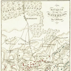
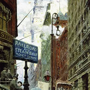
Plan of the Battle of Waterloo, June 16-18, 1815. From Historical Atlas, published 1923

![]()
Wall Art and Photo Gifts from Fine Art Finder
Plan of the Battle of Waterloo, June 16-18, 1815. From Historical Atlas, published 1923
2603479 Plan of the Battle of Waterloo, June 16-18, 1815. From Historical Atlas, published 1923
Media ID 38090634
© Bridgeman Images
1815 Chart Coalition June Military Strategy Napoleonic Napoleonic Battle Napoleonic Conquest Napoleonic War Napoleonic Wars Napoleonic Wars 1804 1815 Positions Seventh Strategy Tactics War Strategy Wars Waterloo
FEATURES IN THESE COLLECTIONS
> Europe
> Belgium
> Related Images
> Fine Art Finder
> Artists
> Thornton Oakley
> Historic
> Battles
> Battle of Waterloo
> Map of the Waterloo campaign
> Historic
> Battles
> Battle of Waterloo
> Military strategy
> Historic
> Battles
> Battle of Waterloo
> Strategy and planning
> Maps and Charts
> Early Maps
> Popular Themes
> Battle of Waterloo
EDITORS COMMENTS
This stunning print captures the intricate Plan of the Battle of Waterloo, which took place on June 16-18, 1815. Published in a Historical Atlas in 1923, this detailed map provides a glimpse into one of the most significant battles in European history.
The Battle of Waterloo was a pivotal moment in the Napoleonic Wars, marking the final defeat of Napoleon Bonaparte. This strategic confrontation took place on Belgian soil and involved intense military tactics and warfare.
The colors used in this map bring to life the positions and movements of troops during this historic battle. The coalition forces, led by British Duke of Wellington and Prussian Field Marshal Blücher, successfully defeated Napoleon's army after days of fierce fighting.
This print serves as a valuable historical document, showcasing not only the geographical layout of the battlefield but also highlighting key aspects of war strategy and military tactics employed during that time period.
As we study this map closely, we can appreciate the complexities involved in planning and executing such large-scale military campaigns. It is a reminder of the sacrifices made by soldiers on both sides and serves as a testament to human resilience and determination in times of conflict.
MADE IN AUSTRALIA
Safe Shipping with 30 Day Money Back Guarantee
FREE PERSONALISATION*
We are proud to offer a range of customisation features including Personalised Captions, Color Filters and Picture Zoom Tools
SECURE PAYMENTS
We happily accept a wide range of payment options so you can pay for the things you need in the way that is most convenient for you
* Options may vary by product and licensing agreement. Zoomed Pictures can be adjusted in the Cart.