Home > North America > Nicaragua > Maps
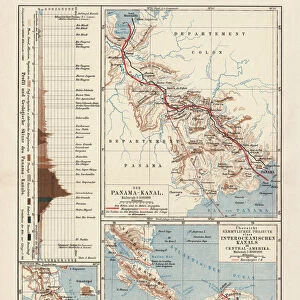
An 1870 map showing the proposed route of the The Nicaraguan Canal, a planned shipping route through Nicaragua to connect the Caribbean Sea, and therefore the Atlantic Ocean, with the Pacific Ocean

![]()
Wall Art and Photo Gifts from Fine Art Finder
An 1870 map showing the proposed route of the The Nicaraguan Canal, a planned shipping route through Nicaragua to connect the Caribbean Sea, and therefore the Atlantic Ocean, with the Pacific Ocean
UIG5419658 An 1870 map showing the proposed route of the The Nicaraguan Canal, a planned shipping route through Nicaragua to connect the Caribbean Sea, and therefore the Atlantic Ocean, with the Pacific Ocean. From The History of Our Country, published 1900 ©UIG/Leemage
Media ID 38282412
© Bridgeman Images
Atlantic Ocean Canal Caribbean Caribbean Island Carribean
FEATURES IN THESE COLLECTIONS
> Fine Art Finder
> Artists
> William Anderson
> Maps and Charts
> Related Images
> North America
> Nicaragua
> Maps
> North America
> Nicaragua
> Related Images
> North America
> United States of America
> Maps
> Popular Themes
> North Island
EDITORS COMMENTS
This 1870 map showcases the proposed route of the Nicaraguan Canal, a visionary shipping passage that aimed to connect the Caribbean Sea and the Atlantic Ocean with the Pacific Ocean. The intricate details and precision of this historical document provide a glimpse into the ambitious engineering plans of its time.
As you study this map, you can almost feel the excitement and anticipation surrounding this groundbreaking project. The idea of creating a direct waterway between two major oceans must have sparked imaginations and inspired dreams of global connectivity.
The intricacies of planning such an immense canal are evident in every line and measurement on this print. It serves as a testament to human ingenuity and determination to overcome geographical barriers for progress and development.
Looking at this piece, one can't help but marvel at the foresight and innovation that went into envisioning such an undertaking over a century ago. It stands as a reminder of our relentless pursuit of exploration, discovery, and connection across vast expanses of land and sea.
This map is not just a historical artifact; it's a symbol of human ambition reaching beyond borders to unite distant shores through modern engineering marvels.
MADE IN AUSTRALIA
Safe Shipping with 30 Day Money Back Guarantee
FREE PERSONALISATION*
We are proud to offer a range of customisation features including Personalised Captions, Color Filters and Picture Zoom Tools
SECURE PAYMENTS
We happily accept a wide range of payment options so you can pay for the things you need in the way that is most convenient for you
* Options may vary by product and licensing agreement. Zoomed Pictures can be adjusted in the Cart.