Home > Arts > Artists > M > Mexican School Mexican School
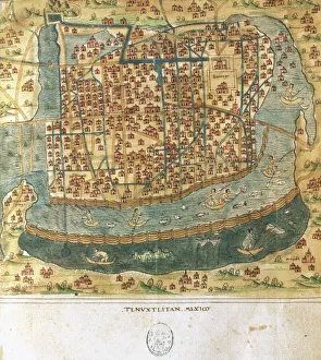
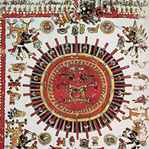
Map of Tenochtitlan from Praeclara Ferdinandi Cortesii de Nova Maris Oceani

![]()
Wall Art and Photo Gifts from Fine Art Finder
Map of Tenochtitlan from Praeclara Ferdinandi Cortesii de Nova Maris Oceani
XJF265826 Map of Tenochtitlan from Praeclara Ferdinandi Cortesii de Nova Maris Oceani Hispania Narrati (woodcut) (b/w photo) by German School, (16th century); Private Collection; (add.info.: Hernando Cortes (1485-1547) Spanish adverturer who was central to the conquest of Mexico; site of Mexico City; ); German, out of copyright
Media ID 12785086
© www.bridgemanart.com
FEATURES IN THESE COLLECTIONS
> Arts
> Artists
> M
> Mexican School Mexican School
> Arts
> Artists
> S
> Spanish School
> Europe
> Germany
> Lakes
> Related Images
> Europe
> Spain
> Related Images
> Fine Art Finder
> Schools
> German School
> Historic
> Ancient civilizations
> Aztec Empire
> Historic
> Aztec temples and carvings
EDITORS COMMENTS
This print showcases a remarkable piece of history - the "Map of Tenochtitlan from Praeclara Ferdinandi Cortesii de Nova Maris Oceani Hispania Narrati". Created by the German School in the 16th century, this woodcut map offers a glimpse into the ancient Aztec capital, Tenochtitlan. The image transports us to a time when Hernando Cortes, the Spanish adventurer, played a pivotal role in Mexico's conquest. The map highlights Tenochtitlan's unique geography as it sits on an island within Lake Texcoco. This floating city was home to grand pyramids and temples that stood proudly against its picturesque backdrop. As we study this intricate cartography, we are reminded of the immense cultural exchange between Spain and the Aztec Empire during this period of exploration. The detailed depiction invites us to imagine bustling streets filled with vibrant markets and breathtaking architecture. This rare find is part of a private collection and serves as an invaluable historical artifact. It not only captures our attention but also sparks curiosity about past civilizations' achievements and their interactions with foreign powers. Through this photograph, we can appreciate both the artistic skill behind creating such maps centuries ago and gain insight into how different cultures shaped one another through exploration and conquest.
MADE IN AUSTRALIA
Safe Shipping with 30 Day Money Back Guarantee
FREE PERSONALISATION*
We are proud to offer a range of customisation features including Personalised Captions, Color Filters and Picture Zoom Tools
SECURE PAYMENTS
We happily accept a wide range of payment options so you can pay for the things you need in the way that is most convenient for you
* Options may vary by product and licensing agreement. Zoomed Pictures can be adjusted in the Cart.