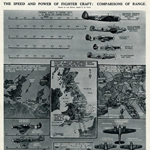
Home > Fine Art Finder > Schools > English School
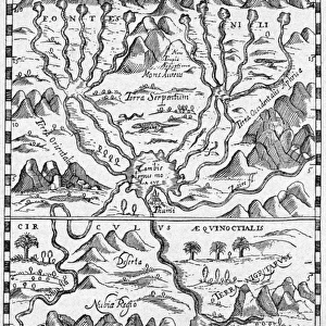
Map of Britain in 665, from The Northumbrian Kingdom 588 to 685 in A Short History

![]()
Wall Art and Photo Gifts from Fine Art Finder
Map of Britain in 665, from The Northumbrian Kingdom 588 to 685 in A Short History
KW392505 Map of Britain in 665, from The Northumbrian Kingdom 588 to 685 in A Short History of the English People by J. R. Green, published 1893 (litho) by English School, (19th century); Private Collection; Ken Welsh; English, out of copyright
Media ID 12871939
© www.bridgemanimages.com
Anglo Saxon C07th Counties County Diagram Early Medieval Mapping Northumbria Region Regions Territories Territory
EDITORS COMMENTS
This print showcases a historical treasure - the Map of Britain in 665. Taken from "The Northumbrian Kingdom 588 to 685 in A Short History of the English People" by J. R. Green, published in 1893, this lithograph offers a glimpse into the past. With intricate details and expert cartography, this map takes us back to early medieval times when Anglo-Saxon rule prevailed. The region is divided into counties, highlighting the supremacy of Wulfhere and his Northumbrian Kingdom during that era. England, Scotland, and Wales are depicted with precision, showcasing their respective territories. As we delve into this illustration's rich history, it becomes evident that it serves as more than just a geographical representation. It symbolizes an era marked by power struggles and shifting alliances among various British kingdoms. The artist's attention to detail allows us to appreciate the complexity of political boundaries during this time period. This map not only provides valuable insights for historians but also sparks curiosity about how these regions evolved over centuries. Preserved within a private collection today, this image transports us back in time while reminding us of our shared heritage as inhabitants of these lands. Its presence on Fine Art Finder ensures its accessibility for those seeking knowledge about British history or simply appreciating the beauty found within historical maps like this one.
MADE IN AUSTRALIA
Safe Shipping with 30 Day Money Back Guarantee
FREE PERSONALISATION*
We are proud to offer a range of customisation features including Personalised Captions, Color Filters and Picture Zoom Tools
SECURE PAYMENTS
We happily accept a wide range of payment options so you can pay for the things you need in the way that is most convenient for you
* Options may vary by product and licensing agreement. Zoomed Pictures can be adjusted in the Cart.