Home > Europe > United Kingdom > Northern Ireland > Maps
Map showing the French dominions of Henry II King of england (print)
")
![]()
Wall Art and Photo Gifts from Fine Art Finder
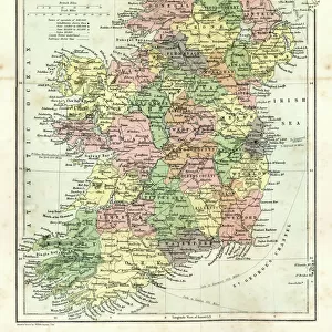
Map showing the French dominions of Henry II King of england (print)
1000965 Map showing the French dominions of Henry II King of england (print); Private Collection; (add.info.: From Illustrated Easy Stories from English History.)
Media ID 38284572
© Bridgeman Images
12 12th Xii Xiith Century 12 Century 12th 12th Century Aquitaine C12th Dominions Geographical Henry House Of Plantagenet King Henry Ii Of England King Of England Mapmaking Plantagenet Possessions Twelfth Twelfth Century Xii Century Xiith Century
FEATURES IN THESE COLLECTIONS
> Europe
> Republic of Ireland
> Maps
> Europe
> United Kingdom
> England
> Maps
> Europe
> United Kingdom
> Maps
> Europe
> United Kingdom
> Northern Ireland
> Maps
> Europe
> United Kingdom
> Northern Ireland
> Posters
> Europe
> United Kingdom
> Northern Ireland
> Related Images
> Fine Art Finder
> Temp Classification
> Maps and Charts
> Early Maps
EDITORS COMMENTS
This print showcases a detailed map illustrating the French dominions of Henry II, King of England during the 12th century. The intricate lines and borders on the map highlight the vast territories controlled by Henry II, including Aquitaine in France.
Henry II, part of the House of Plantagenet, was a powerful ruler who held significant influence over both England and parts of France. This map provides a visual representation of his expansive reign and strategic alliances across Europe.
The black and white aesthetic adds a timeless quality to this historical piece, emphasizing its importance as a valuable artifact from English history. The careful attention to detail by the geographer is evident in every line and symbol on the map.
As we gaze upon this print, we are transported back in time to an era when kingdoms were constantly shifting and battles for dominance were commonplace. It serves as a reminder of the complex political landscape that defined medieval Europe.
Overall, this print is not just a geographical depiction but also a window into the past that allows us to better understand Henry II's legacy as one of England's most influential monarchs.
MADE IN AUSTRALIA
Safe Shipping with 30 Day Money Back Guarantee
FREE PERSONALISATION*
We are proud to offer a range of customisation features including Personalised Captions, Color Filters and Picture Zoom Tools
SECURE PAYMENTS
We happily accept a wide range of payment options so you can pay for the things you need in the way that is most convenient for you
* Options may vary by product and licensing agreement. Zoomed Pictures can be adjusted in the Cart.