Fine Art Print > North America > United States of America > Connecticut > New Haven
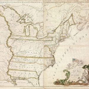
Fine Art Print : Americas first national map, 1784 (hand-coloured engraving)
")

![]()
Fine Art Prints from Fine Art Finder
Americas first national map, 1784 (hand-coloured engraving)
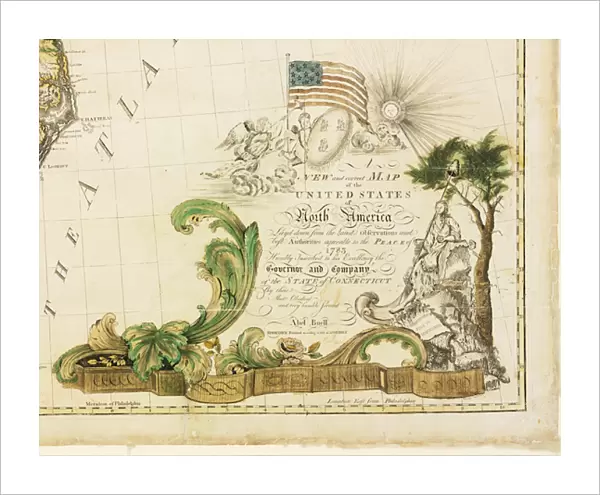
1268149 Americas first national map, 1784 (hand-coloured engraving) by Buell, Abel (1742-1822); 115.2x128.6 cm; Private Collection; (add.info.: New and correct map of the United States of North America layd down from the latest observations and best authorities agreeable to the Peace of 1783, humbly inscribed to his excellency the Governor and Company of the State of Connecticut by their most obedient and very humble servant, Abel Buell, New Haven, 1784); Photo eChristies Images; American, out of copyright
Media ID 22529526
© Christie's Images / Bridgeman Images
1783 Americas Independence Mapping North American Patriotic Territories Territory Treaty Of Paris Peace Of Paris
20"x16" (+3" Border) Fine Art Print
Discover history with our exquisite Fine Art Print of America's first national map from 1784. This hand-coloured engraving, created by Abel Buell, provides a captivating glimpse into the early cartography of the United States. Originally from a private collection, this rare and intricately detailed map is now available as a beautiful addition to your home or office. Bring a piece of historical significance and artistic beauty into your space with the Media Storehouse range of Fine Art Prints.
20x16 image printed on 26x22 Fine Art Rag Paper with 3" (76mm) white border. Our Fine Art Prints are printed on 300gsm 100% acid free, PH neutral paper with archival properties. This printing method is used by museums and art collections to exhibit photographs and art reproductions.
Our fine art prints are high-quality prints made using a paper called Photo Rag. This 100% cotton rag fibre paper is known for its exceptional image sharpness, rich colors, and high level of detail, making it a popular choice for professional photographers and artists. Photo rag paper is our clear recommendation for a fine art paper print. If you can afford to spend more on a higher quality paper, then Photo Rag is our clear recommendation for a fine art paper print.
Estimated Image Size (if not cropped) is 50.8cm x 40.6cm (20" x 16")
Estimated Product Size is 66cm x 55.9cm (26" x 22")
These are individually made so all sizes are approximate
Artwork printed orientated as per the preview above, with landscape (horizontal) orientation to match the source image.
FEATURES IN THESE COLLECTIONS
> Fine Art Finder
> Maps (celestial & Terrestrial)
> Europe
> France
> Paris
> Maps
> Maps and Charts
> Early Maps
> North America
> United States of America
> Connecticut
> New Haven
> North America
> United States of America
> Connecticut
> Related Images
> North America
> United States of America
> Maps
EDITORS COMMENTS
This print showcases America's first national map, created in 1784 by Abel Buell. The hand-coloured engraving measures an impressive 115.2x128.6 cm and is currently held in a private collection. Known as the "New and correct map of the United States of North America" it was meticulously crafted based on the latest observations and best authorities available at that time. The map holds great historical significance, as it accurately represents the territories of North America following the Peace Treaty of 1783, which marked America's independence from British rule. It is humbly dedicated to His Excellency the Governor and Company of Connecticut by Abel Buell himself, showcasing his deep respect for his home state. Every detail on this remarkable piece reflects Buell's dedication to cartography and his patriotic spirit towards a newly formed nation. It serves as a testament to American history, symbolizing both unity and progress during a transformative period. This print allows us to appreciate not only the artistry behind this engraved masterpiece but also its importance in shaping our understanding of early American geography. As we gaze upon this historic artifact, we are transported back to a time when boundaries were being redrawn, paving the way for what would become one of the most influential nations in modern history - The United States of America.
MADE IN AUSTRALIA
Safe Shipping with 30 Day Money Back Guarantee
FREE PERSONALISATION*
We are proud to offer a range of customisation features including Personalised Captions, Color Filters and Picture Zoom Tools
SECURE PAYMENTS
We happily accept a wide range of payment options so you can pay for the things you need in the way that is most convenient for you
* Options may vary by product and licensing agreement. Zoomed Pictures can be adjusted in the Cart.