Fine Art Print > Europe > Denmark > Maps
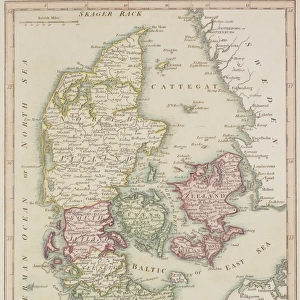
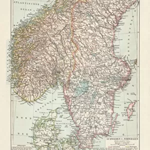
Fine Art Print : Map of Denmark 1900


![]()
Fine Art Prints from Fine Art Storehouse
Map of Denmark 1900
Meyers hand-Atlas Leipzig und Wien Verlag des Bibliographischen Instituts 1900
Unleash your creativity and transform your space into a visual masterpiece!
THEPALMER
Media ID 18106907
© 2014 Roberto Adrian Photography
20"x16" (+3" Border) Fine Art Print
Discover the rich history and intricate details of Denmark with this stunning fine art print from ThePalmer's Map of Denmark, published in 1900 by Meyers Hand-Atlas Leipzig und Wien Verlag des Bibliographischen Instituts. This exquisite piece showcases the cartographic artistry of the time, capturing the political boundaries, geographical features, and cultural nuances of Denmark during the early 20th century. Bring a piece of historical cartography into your home or office and transport yourself back in time with this beautiful fine art print from Media Storehouse.
20x16 image printed on 26x22 Fine Art Rag Paper with 3" (76mm) white border. Our Fine Art Prints are printed on 300gsm 100% acid free, PH neutral paper with archival properties. This printing method is used by museums and art collections to exhibit photographs and art reproductions.
Our fine art prints are high-quality prints made using a paper called Photo Rag. This 100% cotton rag fibre paper is known for its exceptional image sharpness, rich colors, and high level of detail, making it a popular choice for professional photographers and artists. Photo rag paper is our clear recommendation for a fine art paper print. If you can afford to spend more on a higher quality paper, then Photo Rag is our clear recommendation for a fine art paper print.
Estimated Image Size (if not cropped) is 40.6cm x 49.1cm (16" x 19.3")
Estimated Product Size is 55.9cm x 66cm (22" x 26")
These are individually made so all sizes are approximate
Artwork printed orientated as per the preview above, with portrait (vertical) orientation to match the source image.
FEATURES IN THESE COLLECTIONS
> Europe
> Denmark
> Related Images
> Fine Art Storehouse
> Map
> Denmark Maps
> Fine Art Storehouse
> Map
> Historical Maps
EDITORS COMMENTS
In this print titled "Map of Denmark 1900". THEPALMER takes us on a journey back in time to explore the intricate details of a bygone era. This vintage map, sourced from Meyers hand-Atlas Leipzig und Wien Verlag des Bibliographischen Instituts 1900, offers an intriguing glimpse into the geographical landscape and historical context of Denmark at the turn of the century. The artist's meticulous attention to detail is evident as we observe every delicate line and intricately drawn border that defines each region within this beautiful country. The faded hues and aged texture add a sense of nostalgia, inviting viewers to immerse themselves in the rich history embedded within these cartographic lines. As we study this mesmerizing piece, our eyes are drawn to key landmarks such as Copenhagen, Aarhus, Odense, and countless other cities that have witnessed centuries of Danish culture unfold. We can almost imagine ourselves tracing ancient trade routes or envisioning how life might have been for those who inhabited these lands long ago. "The Map of Denmark 1900" serves not only as a visual delight but also as a valuable educational tool for historians and enthusiasts alike. It reminds us of the importance of preserving our past while igniting curiosity about how societies evolve over time. THEPALMER's masterful capture allows us to appreciate both the artistry involved in creating maps during this period and their significance in understanding our world's ever-changing geography.
MADE IN AUSTRALIA
Safe Shipping with 30 Day Money Back Guarantee
FREE PERSONALISATION*
We are proud to offer a range of customisation features including Personalised Captions, Color Filters and Picture Zoom Tools
SECURE PAYMENTS
We happily accept a wide range of payment options so you can pay for the things you need in the way that is most convenient for you
* Options may vary by product and licensing agreement. Zoomed Pictures can be adjusted in the Cart.