Fine Art Print > Maps and Charts > British Empire Maps
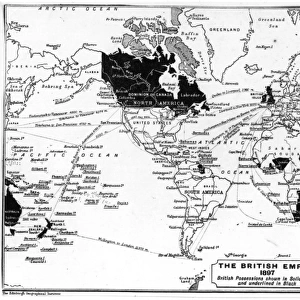
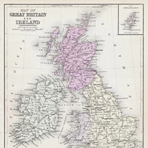
Fine Art Print : The British Empire From 1883


![]()
Fine Art Prints from Fine Art Storehouse
The British Empire From 1883
Map From 1883 Showing The British Empire Throughout The World
Unleash your creativity and transform your space into a visual masterpiece!
traveler1116
Media ID 20172643
© traveler1116
Empire Line Art Retro Revival Sketch
21"x14" (+3" Border) Fine Art Print
Step back in time with our exquisite Fine Art Print of 'The British Empire from 1883' by traveler1116 from the Media Storehouse collection. This captivating map offers a glimpse into the historical expanse of the British Empire at the height of its global influence. The intricate details and vibrant colors bring the past to life, making this a stunning addition to any home or office. Transport yourself on a journey through history with this beautiful and thought-provoking piece.
21x14 image printed on 27x20 Fine Art Rag Paper with 3" (76mm) white border. Our Fine Art Prints are printed on 300gsm 100% acid free, PH neutral paper with archival properties. This printing method is used by museums and art collections to exhibit photographs and art reproductions.
Our fine art prints are high-quality prints made using a paper called Photo Rag. This 100% cotton rag fibre paper is known for its exceptional image sharpness, rich colors, and high level of detail, making it a popular choice for professional photographers and artists. Photo rag paper is our clear recommendation for a fine art paper print. If you can afford to spend more on a higher quality paper, then Photo Rag is our clear recommendation for a fine art paper print.
Estimated Image Size (if not cropped) is 53.3cm x 33cm (21" x 13")
Estimated Product Size is 68.6cm x 50.8cm (27" x 20")
These are individually made so all sizes are approximate
Artwork printed orientated as per the preview above, with landscape (horizontal) orientation to match the source image.
FEATURES IN THESE COLLECTIONS
> Maps and Charts
> British Empire Maps
> Maps and Charts
> Related Images
> Maps and Charts
> World
> Fine Art Storehouse
> Map
> Historical Maps
EDITORS COMMENTS
This print takes us back in time to the grandeur and vastness of the British Empire during its peak in 1883. With a retro revival, 19th-century style, this sketch-like line art captures the essence of an antique map that once adorned the walls of explorers and scholars alike. The intricate details showcased in this piece allow us to marvel at the sheer expanse of territories under British rule, spanning continents and oceans. From India to Africa, Australia to Canada, this map reveals how far-reaching and influential the empire truly was. As we study each carefully drawn border and label, we are transported into a world where colonial powers shaped history through exploration, trade routes, and cultural exchange. It serves as a reminder of both triumphs and controversies associated with imperialism. The artist's skillful execution brings life to every stroke on this print. The delicate lines create depth while maintaining an air of simplicity that is characteristic of 19th-century aesthetics. This artwork effortlessly blends nostalgia with historical significance. Whether displayed in a home library or office space, "The British Empire From 1883" sparks curiosity about our shared past while celebrating human achievements in exploration. It invites viewers to reflect upon global connections forged during an era when borders were redrawn by intrepid travelers seeking new horizons.
MADE IN AUSTRALIA
Safe Shipping with 30 Day Money Back Guarantee
FREE PERSONALISATION*
We are proud to offer a range of customisation features including Personalised Captions, Color Filters and Picture Zoom Tools
SECURE PAYMENTS
We happily accept a wide range of payment options so you can pay for the things you need in the way that is most convenient for you
* Options may vary by product and licensing agreement. Zoomed Pictures can be adjusted in the Cart.