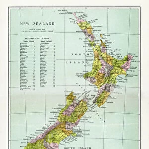
Fine Art Print > Asia > Related Images
Fine Art Print : Map of Asia 1900


![]()
Fine Art Prints from Fine Art Storehouse
Map of Asia 1900
Meyers hand-Atlas Leipzig und Wien Verlag des Bibliographischen Instituts 1900
Unleash your creativity and transform your space into a visual masterpiece!
THEPALMER
Media ID 18106887
© 2014 Roberto Adrian Photography
20"x16" (+3" Border) Fine Art Print
Discover the rich history and cultural diversity of Asia in this stunning vintage map print from the Media Storehouse Fine Art Prints collection. The Map of Asia 1900 by THEPALMER, originally published in the Meyers Hand-Atlas by Bibliographisches Institut Leipzig und Wien Verlag, showcases intricate detail and accurate cartography of the Asian continent as it appeared over a century ago. Bring a piece of historical geography into your home or office with this beautiful and intriguing work of art.
20x16 image printed on 26x22 Fine Art Rag Paper with 3" (76mm) white border. Our Fine Art Prints are printed on 300gsm 100% acid free, PH neutral paper with archival properties. This printing method is used by museums and art collections to exhibit photographs and art reproductions.
Our fine art prints are high-quality prints made using a paper called Photo Rag. This 100% cotton rag fibre paper is known for its exceptional image sharpness, rich colors, and high level of detail, making it a popular choice for professional photographers and artists. Photo rag paper is our clear recommendation for a fine art paper print. If you can afford to spend more on a higher quality paper, then Photo Rag is our clear recommendation for a fine art paper print.
Estimated Image Size (if not cropped) is 50.8cm x 40.6cm (20" x 16")
Estimated Product Size is 66cm x 55.9cm (26" x 22")
These are individually made so all sizes are approximate
Artwork printed orientated as per the preview above, with landscape (horizontal) orientation to match the source image.
FEATURES IN THESE COLLECTIONS
> Asia
> Related Images
> Fine Art Storehouse
> Map
> Historical Maps
EDITORS COMMENTS
In this print titled "Map of Asia 1900" we are transported back in time to the turn of the century. The intricate details and vibrant colors of this vintage map, sourced from Meyers Hand-Atlas Leipzig und Wien Verlag des Bibliographischen Instituts in 1900, truly bring history to life. As our eyes wander across the expanse of Asia depicted on this map, we are reminded of a world that was vastly different from what we know today. Borders have shifted, empires have risen and fallen, and cultures have evolved over time. This snapshot offers us a glimpse into an era where exploration and discovery were at their peak. The meticulous craftsmanship evident in every line and label showcases the dedication and expertise required to create such a masterpiece. It is a testament to both the artistry involved in cartography as well as its importance for understanding our place within the world. "The Map of Asia 1900" by THEPALMER invites us to embark on a journey through time, sparking curiosity about past civilizations while highlighting how geography has shaped human history. Whether displayed as part of an educational setting or simply admired for its aesthetic appeal, this print serves as a visual reminder that maps not only guide us but also tell stories waiting to be explored.
MADE IN AUSTRALIA
Safe Shipping with 30 Day Money Back Guarantee
FREE PERSONALISATION*
We are proud to offer a range of customisation features including Personalised Captions, Color Filters and Picture Zoom Tools
SECURE PAYMENTS
We happily accept a wide range of payment options so you can pay for the things you need in the way that is most convenient for you
* Options may vary by product and licensing agreement. Zoomed Pictures can be adjusted in the Cart.