Fine Art Print > Fine Art Storehouse > Map
Fine Art Print : Map of Mexico and Central america 1886


![]()
Fine Art Prints from Fine Art Storehouse
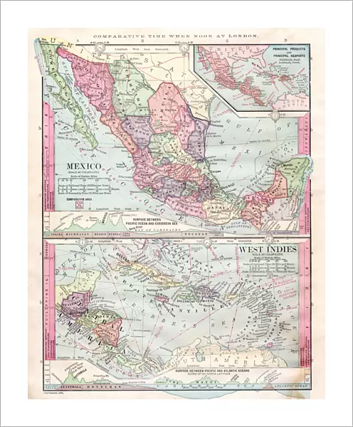
Map of Mexico and Central america 1886
Unleash your creativity and transform your space into a visual masterpiece!
THEPALMER
Media ID 14757032
© This content is subject to copyright
20"x16" (+3" Border) Fine Art Print
Discover the rich history and cultural beauty of Mexico and Central America with this stunning 1886 map print from THEPALMER's Fine Art Storehouse collection. This intricately detailed map, showcasing the regions during a pivotal time in their history, makes for an exquisite addition to any home or office decor. Bring a piece of the past into your space and transport yourself on a journey through time with this fine art print.
20x16 image printed on 26x22 Fine Art Rag Paper with 3" (76mm) white border. Our Fine Art Prints are printed on 300gsm 100% acid free, PH neutral paper with archival properties. This printing method is used by museums and art collections to exhibit photographs and art reproductions.
Our fine art prints are high-quality prints made using a paper called Photo Rag. This 100% cotton rag fibre paper is known for its exceptional image sharpness, rich colors, and high level of detail, making it a popular choice for professional photographers and artists. Photo rag paper is our clear recommendation for a fine art paper print. If you can afford to spend more on a higher quality paper, then Photo Rag is our clear recommendation for a fine art paper print.
Estimated Image Size (if not cropped) is 40.6cm x 50.8cm (16" x 20")
Estimated Product Size is 55.9cm x 66cm (22" x 26")
These are individually made so all sizes are approximate
Artwork printed orientated as per the preview above, with portrait (vertical) orientation to match the source image.
FEATURES IN THESE COLLECTIONS
> Fine Art Storehouse
> Map
> Historical Maps
EDITORS COMMENTS
This print showcases a remarkable piece of history, the "Map of Mexico and Central America 1886". Created by THEPALMER, this exquisite artwork takes us back in time to an era when cartography was both an art form and a scientific endeavor. The map itself is a testament to the meticulous craftsmanship and attention to detail that went into its creation. As we gaze upon this vintage treasure, we are transported to the late 19th century, where borders were still being defined and explored. Every inch of this map is filled with intricate illustrations depicting cities, rivers, mountains, and coastlines. It serves as a visual guide through the diverse landscapes of Mexico and Central America during that period. The sepia tones add an air of nostalgia to the image, reminding us of days gone by. This particular print from Fine Art Storehouse captures every fine line and delicate curve with utmost precision. It allows us to appreciate not only the geographical accuracy but also the artistic beauty embedded within each stroke. Whether you are a history enthusiast or simply captivated by old-world charm, this Map of Mexico and Central America 1886 will surely transport you on a journey through time. Hang it proudly on your wall as both an educational tool for geography enthusiasts or as a stunning conversation starter for any room in your home.
MADE IN AUSTRALIA
Safe Shipping with 30 Day Money Back Guarantee
FREE PERSONALISATION*
We are proud to offer a range of customisation features including Personalised Captions, Color Filters and Picture Zoom Tools
SECURE PAYMENTS
We happily accept a wide range of payment options so you can pay for the things you need in the way that is most convenient for you
* Options may vary by product and licensing agreement. Zoomed Pictures can be adjusted in the Cart.