Fine Art Print > Fine Art Storehouse > Map
Fine Art Print : Map of middle atlantic states 1881


![]()
Fine Art Prints from Fine Art Storehouse
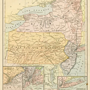
Map of middle atlantic states 1881
Harpers School Geography, New York, Harpers and Brothers, 1881
Unleash your creativity and transform your space into a visual masterpiece!
THEPALMER
Media ID 14756106
© This content is subject to copyright
Maryland New Jersey New York Ontario Pennsylvania United States
20"x16" (+3" Border) Fine Art Print
Step back in time with this exquisite Fine Art Print from Media Storehouse. Featuring the intricately detailed "Map of the Middle Atlantic States" by THEPALMER, originally published in Harpers School Geography, New York, Harpers and Brothers, 1881. This vintage map transports you to a bygone era with its charming antique aesthetic and meticulous cartography. A must-have for history buffs, geography enthusiasts, or anyone who appreciates the beauty of historical art. Add a touch of timeless charm to your home or office with this stunning Fine Art Print from Media Storehouse.
20x16 image printed on 26x22 Fine Art Rag Paper with 3" (76mm) white border. Our Fine Art Prints are printed on 300gsm 100% acid free, PH neutral paper with archival properties. This printing method is used by museums and art collections to exhibit photographs and art reproductions.
Our fine art prints are high-quality prints made using a paper called Photo Rag. This 100% cotton rag fibre paper is known for its exceptional image sharpness, rich colors, and high level of detail, making it a popular choice for professional photographers and artists. Photo rag paper is our clear recommendation for a fine art paper print. If you can afford to spend more on a higher quality paper, then Photo Rag is our clear recommendation for a fine art paper print.
Estimated Image Size (if not cropped) is 40.6cm x 50.8cm (16" x 20")
Estimated Product Size is 55.9cm x 66cm (22" x 26")
These are individually made so all sizes are approximate
Artwork printed orientated as per the preview above, with portrait (vertical) orientation to match the source image.
FEATURES IN THESE COLLECTIONS
> Fine Art Storehouse
> Map
> Historical Maps
EDITORS COMMENTS
In this photo print, we are transported back to the year 1881, as we explore a vintage map of the Middle Atlantic states. Taken from Harper's School Geography, New York, published by Harpers and Brothers in that very same year, this piece offers us a glimpse into the past and invites us to embark on a historical journey. The intricate details of this map beautifully showcase Maryland, New Jersey, New York, Ontario (Canada), Pennsylvania, and other neighboring regions. The careful craftsmanship is evident in every stroke of ink and delicate contour line. As our eyes wander across the aged parchment-like paper, we can almost imagine ourselves tracing the paths of early settlers or envisioning bustling cities emerging amidst vast landscapes. This particular print carries an air of authenticity that only time can bestow upon such artifacts. Its weathered appearance adds character and charm to any space it graces. Whether displayed in a cozy study or an elegant living room setting, it serves as both a decorative centerpiece and an educational tool for history enthusiasts. "The Map of Middle Atlantic States 1881" by THEPALMER captures not only geographical boundaries but also echoes whispers from another era—a testament to human exploration and progress throughout centuries gone by. It reminds us that beneath our modern lives lie layers upon layers of stories waiting to be discovered—a treasure trove for those who dare to delve into the rich tapestry woven by our ancestors' footsteps.
MADE IN AUSTRALIA
Safe Shipping with 30 Day Money Back Guarantee
FREE PERSONALISATION*
We are proud to offer a range of customisation features including Personalised Captions, Color Filters and Picture Zoom Tools
SECURE PAYMENTS
We happily accept a wide range of payment options so you can pay for the things you need in the way that is most convenient for you
* Options may vary by product and licensing agreement. Zoomed Pictures can be adjusted in the Cart.