Fine Art Print > Maps and Charts > Africa
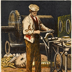
Fine Art Print : Mountain and Hydrographic Map of Africa


![]()
Fine Art Prints from Fine Art Storehouse
Mountain and Hydrographic Map of Africa
Illustration of a Mountain and Hydrographic Map of Africa
Unleash your creativity and transform your space into a visual masterpiece!
Nastasic
Media ID 14756498
© This content is subject to copyright
20"x16" (+3" Border) Fine Art Print
Experience the breathtaking beauty of the natural world with our exquisite Mountain and Hydrographic Map of Africa print from Nastasic's Fine Art Storehouse collection. This stunning artwork masterfully combines the majesty of towering mountains with the intricate detail of an African hydrographic map. Each print is meticulously crafted using high-quality materials and printing techniques to bring out the vibrant colors and intricate details. Hang this captivating piece in your home or office to add a touch of sophistication and worldly charm to any space.
20x16 image printed on 26x22 Fine Art Rag Paper with 3" (76mm) white border. Our Fine Art Prints are printed on 300gsm 100% acid free, PH neutral paper with archival properties. This printing method is used by museums and art collections to exhibit photographs and art reproductions.
Our fine art prints are high-quality prints made using a paper called Photo Rag. This 100% cotton rag fibre paper is known for its exceptional image sharpness, rich colors, and high level of detail, making it a popular choice for professional photographers and artists. Photo rag paper is our clear recommendation for a fine art paper print. If you can afford to spend more on a higher quality paper, then Photo Rag is our clear recommendation for a fine art paper print.
Estimated Image Size (if not cropped) is 50.8cm x 40.6cm (20" x 16")
Estimated Product Size is 66cm x 55.9cm (26" x 22")
These are individually made so all sizes are approximate
Artwork printed orientated as per the preview above, with landscape (horizontal) orientation to match the source image.
FEATURES IN THESE COLLECTIONS
> Africa
> Related Images
> Maps and Charts
> Related Images
> Fine Art Storehouse
> Map
> Historical Maps
EDITORS COMMENTS
This print titled "Mountain and Hydrographic Map of Africa" by Nastasic takes us on a visual journey across the vast and diverse continent. The artwork beautifully combines elements of cartography and illustration, creating a stunning representation of Africa's majestic landscapes. The focal point of the image is an intricately detailed map that showcases the hydrography and topography of Africa. From towering mountain ranges to winding rivers, every contour is meticulously depicted, inviting viewers to explore the continent's natural wonders. The artist's skillful use of colors adds depth and dimension to this intricate piece, allowing us to appreciate the varied terrain that defines Africa. As we gaze upon this artwork, our eyes are drawn towards the mountains dominating the scene. Their grandeur evokes a sense of awe and reverence for nature's power. We can almost feel ourselves standing at their base, marveling at their sheer magnitude. Beyond its geographical significance, this print also serves as a reminder of Africa's rich cultural heritage. It symbolizes unity in diversity as it encompasses numerous countries with distinct traditions and histories. "Nastasic" has masterfully captured both the physical beauty and cultural richness that define Africa in this remarkable artwork. Whether displayed in homes or offices, this print will undoubtedly spark conversations about exploration, adventure, and appreciation for our planet's incredible diversity.
MADE IN AUSTRALIA
Safe Shipping with 30 Day Money Back Guarantee
FREE PERSONALISATION*
We are proud to offer a range of customisation features including Personalised Captions, Color Filters and Picture Zoom Tools
SECURE PAYMENTS
We happily accept a wide range of payment options so you can pay for the things you need in the way that is most convenient for you
* Options may vary by product and licensing agreement. Zoomed Pictures can be adjusted in the Cart.