Fine Art Print > Fine Art Storehouse > Map
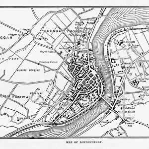
Fine Art Print : Oxford and Buckingham map 1885


![]()
Fine Art Prints from Fine Art Storehouse
Oxford and Buckingham map 1885
Encyclopedia Britannica 9th Edition New York Charles Scribners and Sons 1885 Vol XVIII
Unleash your creativity and transform your space into a visual masterpiece!
THEPALMER
Media ID 14549427
© This content is subject to copyright
20"x16" (+3" Border) Fine Art Print
Step back in time with this exquisite Fine Art Print from Media Storehouse. Featuring an intricately detailed map of Oxford and Buckingham from the Encyclopedia Britannica 9th Edition, published by Charles Scribner's Sons in New York in 1885. The map, created by THEPALMER, showcases the historical layout of these iconic English cities with meticulous accuracy. Bring a piece of history into your home or office with this stunning, museum-quality print. Perfect for those who appreciate the beauty of vintage cartography and the rich history of these renowned universities.
20x16 image printed on 26x22 Fine Art Rag Paper with 3" (76mm) white border. Our Fine Art Prints are printed on 300gsm 100% acid free, PH neutral paper with archival properties. This printing method is used by museums and art collections to exhibit photographs and art reproductions.
Our fine art prints are high-quality prints made using a paper called Photo Rag. This 100% cotton rag fibre paper is known for its exceptional image sharpness, rich colors, and high level of detail, making it a popular choice for professional photographers and artists. Photo rag paper is our clear recommendation for a fine art paper print. If you can afford to spend more on a higher quality paper, then Photo Rag is our clear recommendation for a fine art paper print.
Estimated Image Size (if not cropped) is 35.4cm x 50.8cm (13.9" x 20")
Estimated Product Size is 55.9cm x 66cm (22" x 26")
These are individually made so all sizes are approximate
Artwork printed orientated as per the preview above, with portrait (vertical) orientation to match the source image.
FEATURES IN THESE COLLECTIONS
> Fine Art Storehouse
> Map
> Historical Maps
EDITORS COMMENTS
This print titled "Oxford and Buckingham map 1885" takes us back in time to the late 19th century, offering a glimpse into the rich history and intricate details of these iconic British locations. The image is sourced from the Encyclopedia Britannica's 9th Edition, published by Charles Scribners and Sons in New York in 1885. The map showcases an exquisite level of craftsmanship, meticulously depicting the cities of Oxford and Buckingham along with their surrounding areas. Every street, building, park, and river is intricately illustrated, inviting us to explore this bygone era through cartographic artistry. As we delve into this historical masterpiece captured by THEPALMER for Fine Art Storehouse, we are transported to a time when horse-drawn carriages roamed these streets and grand architecture adorned every corner. The attention to detail allows us to appreciate not only the layout of these cities but also their cultural significance during that period. Whether you have a personal connection to Oxford or Buckingham or simply admire European history at large, this print serves as a window into our past. It sparks curiosity about how life might have been in these bustling towns over a century ago. Displaying this artwork on your wall will undoubtedly evoke conversations about heritage, architecture, and nostalgia among friends and family alike. Let it transport you back in time as you immerse yourself in the beauty of Oxford and Buckingham's yesteryears through this remarkable visual representation.
MADE IN AUSTRALIA
Safe Shipping with 30 Day Money Back Guarantee
FREE PERSONALISATION*
We are proud to offer a range of customisation features including Personalised Captions, Color Filters and Picture Zoom Tools
SECURE PAYMENTS
We happily accept a wide range of payment options so you can pay for the things you need in the way that is most convenient for you
* Options may vary by product and licensing agreement. Zoomed Pictures can be adjusted in the Cart.