Fine Art Print > Maps and Charts > Related Images
Fine Art Print : Peoples map of the earth from 19th century


![]()
Fine Art Prints from Fine Art Storehouse
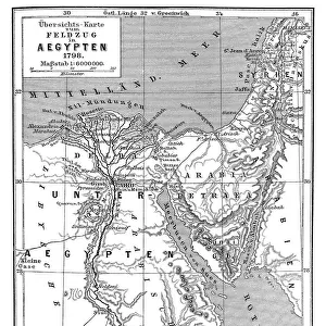
Peoples map of the earth from 19th century
Illustration of a Peoples map of the earth from 19th century
Unleash your creativity and transform your space into a visual masterpiece!
Nastasic
Media ID 18433959
21"x14" (+3" Border) Fine Art Print
Step back in time with our exquisite selection of Fine Art Prints from Media Storehouse. This captivating piece showcases the "Peoples Map of the Earth" by Nastasic, a fascinating representation of the world as it was perceived in the 19th century. Rich in historical detail and intrigue, this vintage map print is a must-have for history buffs, world explorers, and those who appreciate the beauty of the past. Bring a piece of history into your home or office and start a conversation with this stunning work of art.
21x14 image printed on 27x20 Fine Art Rag Paper with 3" (76mm) white border. Our Fine Art Prints are printed on 300gsm 100% acid free, PH neutral paper with archival properties. This printing method is used by museums and art collections to exhibit photographs and art reproductions.
Our fine art prints are high-quality prints made using a paper called Photo Rag. This 100% cotton rag fibre paper is known for its exceptional image sharpness, rich colors, and high level of detail, making it a popular choice for professional photographers and artists. Photo rag paper is our clear recommendation for a fine art paper print. If you can afford to spend more on a higher quality paper, then Photo Rag is our clear recommendation for a fine art paper print.
Estimated Image Size (if not cropped) is 53.3cm x 35.5cm (21" x 14")
Estimated Product Size is 68.6cm x 50.8cm (27" x 20")
These are individually made so all sizes are approximate
Artwork printed orientated as per the preview above, with landscape (horizontal) orientation to match the source image.
FEATURES IN THESE COLLECTIONS
> Maps and Charts
> Related Images
> Fine Art Storehouse
> Map
> Historical Maps
EDITORS COMMENTS
This print showcases an exquisite illustration of a Peoples map of the earth from the 19th century. Created by the talented artist Nastasic, this piece takes us on a journey back in time to explore how people perceived and understood our planet during that era. The intricate details and vibrant colors of this artwork transport us to a world where cartography was still evolving. The map is adorned with delicate drawings, depicting various cultures, landmarks, and natural wonders across different continents. It offers a fascinating glimpse into the diverse societies and civilizations that inhabited our Earth centuries ago. As we gaze upon this remarkable print, we can't help but marvel at the level of craftsmanship displayed by Nastasic. Each stroke seems purposeful, carefully capturing not only geographical features but also cultural nuances unique to each region depicted. This image serves as a reminder of how far humanity has come in terms of exploration and understanding our planet's vastness. It sparks curiosity about what has changed since then while igniting appreciation for those who paved the way for modern geography. Whether you are an art enthusiast or history buff, this print will undoubtedly captivate your imagination and transport you to an era when maps were not just tools for navigation but gateways to discovery.
MADE IN AUSTRALIA
Safe Shipping with 30 Day Money Back Guarantee
FREE PERSONALISATION*
We are proud to offer a range of customisation features including Personalised Captions, Color Filters and Picture Zoom Tools
SECURE PAYMENTS
We happily accept a wide range of payment options so you can pay for the things you need in the way that is most convenient for you
* Options may vary by product and licensing agreement. Zoomed Pictures can be adjusted in the Cart.