Fine Art Print > Asia > Philippines > Maps
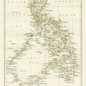
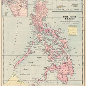
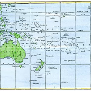
Fine Art Print : Philippines islands map 1898


![]()
Fine Art Prints from Fine Art Storehouse
Philippines islands map 1898
Unleash your creativity and transform your space into a visual masterpiece!
THEPALMER
Media ID 14756928
© This content is subject to copyright
20"x16" (+3" Border) Fine Art Print
Discover the rich history of the Philippines with this stunning Fine Art Print of the Philippines Islands Map from 1898 by THEPALMER. This intricately detailed map transports you back in time, showcasing the archipelago as it appeared during a pivotal moment in its history. The muted colors and vintage aesthetic add an air of nostalgia, making this print a beautiful addition to any home or office. Bring a piece of the past into your space and ignite conversation with this unique and captivating work of art.
20x16 image printed on 26x22 Fine Art Rag Paper with 3" (76mm) white border. Our Fine Art Prints are printed on 300gsm 100% acid free, PH neutral paper with archival properties. This printing method is used by museums and art collections to exhibit photographs and art reproductions.
Our fine art prints are high-quality prints made using a paper called Photo Rag. This 100% cotton rag fibre paper is known for its exceptional image sharpness, rich colors, and high level of detail, making it a popular choice for professional photographers and artists. Photo rag paper is our clear recommendation for a fine art paper print. If you can afford to spend more on a higher quality paper, then Photo Rag is our clear recommendation for a fine art paper print.
Estimated Image Size (if not cropped) is 40.6cm x 50.8cm (16" x 20")
Estimated Product Size is 55.9cm x 66cm (22" x 26")
These are individually made so all sizes are approximate
Artwork printed orientated as per the preview above, with portrait (vertical) orientation to match the source image.
FEATURES IN THESE COLLECTIONS
> Asia
> Philippines
> Maps
> Asia
> Philippines
> Related Images
> Maps and Charts
> Related Images
> Fine Art Storehouse
> Map
> Historical Maps
EDITORS COMMENTS
This print titled "Philippines islands map 1898" takes us on a journey back in time to the year when the Philippines was under American rule. The intricate details and historical significance of this map make it a true gem for history enthusiasts and art lovers alike. The image showcases an exquisite reproduction of the original 1898 map, meticulously crafted by THEPALMER. Every contour, coastline, and island is beautifully depicted, offering a glimpse into the archipelago's geography during that era. The fine lines and delicate shading bring out the rich topography of these enchanting islands. As we gaze upon this piece, our imagination transports us to a time when colonial powers were shaping the destiny of nations. It serves as a reminder of how borders have evolved over time and how cultures have intertwined within these lands. The artist's attention to detail is evident in every stroke, capturing not only geographical accuracy but also evoking emotions associated with exploration and discovery. This artwork invites viewers to delve deeper into Philippine history while appreciating its aesthetic appeal. Whether displayed in homes or educational institutions, this print from Fine Art Storehouse sparks conversations about heritage, identity, and our collective past. It stands as both an artistic masterpiece and an invaluable historical artifact that connects us with our roots.
MADE IN AUSTRALIA
Safe Shipping with 30 Day Money Back Guarantee
FREE PERSONALISATION*
We are proud to offer a range of customisation features including Personalised Captions, Color Filters and Picture Zoom Tools
SECURE PAYMENTS
We happily accept a wide range of payment options so you can pay for the things you need in the way that is most convenient for you
* Options may vary by product and licensing agreement. Zoomed Pictures can be adjusted in the Cart.