Fine Art Print > Arts > Photorealistic artworks > Detailed art pieces > Masterful detailing in art
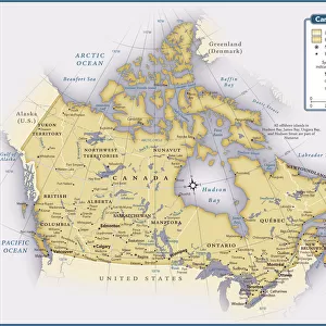
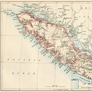
Fine Art Print : Canada Map - illustration


Resolution may be poor at this size (99 DPI)
![]()
Fine Art Prints from Fine Art Storehouse
Canada Map - illustration
Colored Map of the Canada The urls of the reference files are (country, continent, world map and globe): http:/lib.utexas.edu/maps/americas/canada_pol99.jpg http:/lib.utexas.edu/maps/world_maps/time_zones_ref_2011.pdf http:/lib.utexas.edu/maps/americas/north_america_ref_2010.pdf. In addition - some region boundaries and city locations were taken from: http:/lib.utexas.edu/maps/united_states/usa_pol01.jpg http:/lib.utexas.edu/maps/americas/mexico_pol97.jpg http:/lib.utexas.edu/maps/americas/canada_pol_1986.gif - The illustration was completed January 10, 2016 and created in Corel Draw - 1 layer of data used for the detailed outline of the land
Unleash your creativity and transform your space into a visual masterpiece!
Media ID 14777519
20"x16" (+3" Border) Fine Art Print
"Discover the beauty of Canada with our exquisite Fine Art Prints from Media Storehouse. This captivating illustration of a colored map of Canada is a testament to the diverse landscapes and rich history of this magnificent country. Each print is meticulously crafted to bring out the intricate details of the map, transporting you on a visual journey across Canada's vast expanses. Perfect for adding a touch of culture and sophistication to your home or office, these Fine Art Prints are sure to be a conversation starter. Explore our collection and let the wonders of Canada inspire you." Reference files: [Canada Map](http://lib.utexas.edu/maps/americas/canada_pol99.jpg) [Canada - Country](http://) [Canada - Continent](http://) [Canada - World Map](http://) [Canada - Globe](http://)
20x16 image printed on 26x22 Fine Art Rag Paper with 3" (76mm) white border. Our Fine Art Prints are printed on 300gsm 100% acid free, PH neutral paper with archival properties. This printing method is used by museums and art collections to exhibit photographs and art reproductions.
Our fine art prints are high-quality prints made using a paper called Photo Rag. This 100% cotton rag fibre paper is known for its exceptional image sharpness, rich colors, and high level of detail, making it a popular choice for professional photographers and artists. Photo rag paper is our clear recommendation for a fine art paper print. If you can afford to spend more on a higher quality paper, then Photo Rag is our clear recommendation for a fine art paper print.
Estimated Image Size (if not cropped) is 45.6cm x 40.6cm (18" x 16")
Estimated Product Size is 66cm x 55.9cm (26" x 22")
These are individually made so all sizes are approximate
Artwork printed orientated as per the preview above, with landscape (horizontal) orientation to match the source image.
FEATURES IN THESE COLLECTIONS
> Arts
> Photorealistic artworks
> Detailed art pieces
> Masterful detailing in art
> Europe
> France
> Canton
> Landes
> Maps and Charts
> Related Images
> Maps and Charts
> World
> North America
> Canada
> Maps
> North America
> Canada
> Related Images
> Fine Art Storehouse
> Map
> Map Illustrations
EDITORS COMMENTS
This vibrant and detailed illustration of the Canada Map is a true masterpiece. Created in Corel Draw, this print showcases the beauty and diversity of Canada's vast landscapes. The colored map highlights the country's provinces and territories, providing an accurate representation of its geographical boundaries. The artist meticulously incorporated various reference files to ensure accuracy. The country, continent, world map, and globe were all used as references to capture every intricate detail. Additionally, region boundaries and city locations were taken from maps of the United States and Mexico. Completed on January 10,2016, this artwork demonstrates the artist's dedication to precision. With one layer of data used for the detailed outline of the land, it showcases their expertise in creating visually stunning illustrations. Whether you are a geography enthusiast or simply appreciate fine art prints that celebrate our beautiful planet, this Canada Map illustration is sure to captivate your attention. Hang it proudly on your wall as a reminder of Canada's diverse landscapes or gift it to someone who shares your love for exploration.
MADE IN AUSTRALIA
Safe Shipping with 30 Day Money Back Guarantee
FREE PERSONALISATION*
We are proud to offer a range of customisation features including Personalised Captions, Color Filters and Picture Zoom Tools
SECURE PAYMENTS
We happily accept a wide range of payment options so you can pay for the things you need in the way that is most convenient for you
* Options may vary by product and licensing agreement. Zoomed Pictures can be adjusted in the Cart.