Fine Art Print > Asia > Philippines > Maps
Fine Art Print : Philippines map 1898


![]()
Fine Art Prints from Fine Art Storehouse
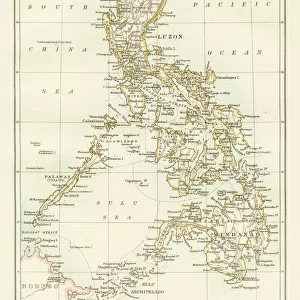
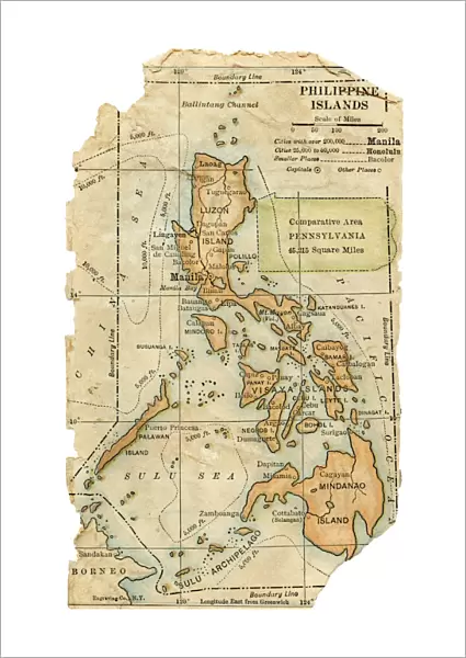
Philippines map 1898
Map from Physical Geography by R. S. Tarr - The MacMillan Company - London 1898
Unleash your creativity and transform your space into a visual masterpiece!
THEPALMER
Media ID 20773159
21"x14" (+3" Border) Fine Art Print
Discover the rich history of the Philippines with this stunning Fine Art Print from Media Storehouse. Featuring an intricately detailed map of the Philippines from the 1898 edition of "Physical Geography" by R.S. Tarr, published by The MacMillan Company in London. This vintage map, titled "The Philippines: Map Showing Its Position in the World," transports you back in time, offering a captivating glimpse into the geography and political landscape of the archipelago during a pivotal moment in its history. Bring a piece of the past into your home or office with this beautiful and authentic Fine Art Print from Media Storehouse.
21x14 image printed on 27x20 Fine Art Rag Paper with 3" (76mm) white border. Our Fine Art Prints are printed on 300gsm 100% acid free, PH neutral paper with archival properties. This printing method is used by museums and art collections to exhibit photographs and art reproductions.
Our fine art prints are high-quality prints made using a paper called Photo Rag. This 100% cotton rag fibre paper is known for its exceptional image sharpness, rich colors, and high level of detail, making it a popular choice for professional photographers and artists. Photo rag paper is our clear recommendation for a fine art paper print. If you can afford to spend more on a higher quality paper, then Photo Rag is our clear recommendation for a fine art paper print.
Estimated Image Size (if not cropped) is 33.1cm x 53.3cm (13" x 21")
Estimated Product Size is 50.8cm x 68.6cm (20" x 27")
These are individually made so all sizes are approximate
Artwork printed orientated as per the preview above, with portrait (vertical) orientation to match the source image.
FEATURES IN THESE COLLECTIONS
> Asia
> Philippines
> Maps
> Asia
> Philippines
> Related Images
> Maps and Charts
> Related Images
EDITORS COMMENTS
This print showcases a historical gem, the Philippines map from 1898. A true testament to the rich tapestry of our world's history, this particular map was featured in "Physical Geography" by R. S. Tarr and published by The MacMillan Company in London back in 1898. With its intricate details and delicate craftsmanship, it offers a glimpse into the past, allowing us to explore how our understanding of geography has evolved over time. The Philippines map takes center stage as it unfolds before our eyes, revealing an archipelago brimming with natural wonders and cultural diversity. Each island is meticulously depicted, highlighting their unique shapes and sizes. From Luzon to Mindanao, one can trace the contours of these lands that have witnessed countless stories unfold throughout centuries. As we delve deeper into this vintage masterpiece captured by THEPALMER for Fine Art Storehouse, we are transported back to an era when cartography was both artistry and science intertwined. This print serves as a reminder of the importance placed on exploration and discovery during that period. Whether you are a history enthusiast or simply appreciate fine art prints that tell tales of yesteryears, this Philippines map from 1898 will surely captivate your imagination. It invites us to reflect upon our roots while igniting curiosity about how far we have come since then - both geographically and culturally.
MADE IN AUSTRALIA
Safe Shipping with 30 Day Money Back Guarantee
FREE PERSONALISATION*
We are proud to offer a range of customisation features including Personalised Captions, Color Filters and Picture Zoom Tools
SECURE PAYMENTS
We happily accept a wide range of payment options so you can pay for the things you need in the way that is most convenient for you
* Options may vary by product and licensing agreement. Zoomed Pictures can be adjusted in the Cart.