Fine Art Print > North America > United States of America > Maps
Fine Art Print : Map of USA 1889


![]()
Fine Art Prints from Fine Art Storehouse
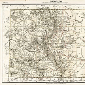
Map of USA 1889
Comprehensive Geography by James Monteith - American Book Company 1882, 1889
Unleash your creativity and transform your space into a visual masterpiece!
THEPALMER
Media ID 18357293
21"x14" (+3" Border) Fine Art Print
Discover the captivating allure of history with our exquisite Map of USA 1889 print from THEPALMER's collection at Fine Art Storehouse. This intricately detailed map, originally published in Comprehensive Geography by James Monteith - American Book Company in 1882 and 1889, offers a fascinating glimpse into the geography of the United States during a pivotal period in its history. With vibrant colors and meticulous craftsmanship, this fine art print is not just a decorative piece, but a window into the past. Bring history to life in your home or office and transport yourself back in time with this stunning representation of the USA in 1889.
21x14 image printed on 27x20 Fine Art Rag Paper with 3" (76mm) white border. Our Fine Art Prints are printed on 300gsm 100% acid free, PH neutral paper with archival properties. This printing method is used by museums and art collections to exhibit photographs and art reproductions.
Our fine art prints are high-quality prints made using a paper called Photo Rag. This 100% cotton rag fibre paper is known for its exceptional image sharpness, rich colors, and high level of detail, making it a popular choice for professional photographers and artists. Photo rag paper is our clear recommendation for a fine art paper print. If you can afford to spend more on a higher quality paper, then Photo Rag is our clear recommendation for a fine art paper print.
Estimated Image Size (if not cropped) is 53.3cm x 27.8cm (21" x 10.9")
Estimated Product Size is 68.6cm x 50.8cm (27" x 20")
These are individually made so all sizes are approximate
Artwork printed orientated as per the preview above, with landscape (horizontal) orientation to match the source image.
FEATURES IN THESE COLLECTIONS
> Maps and Charts
> Related Images
> North America
> United States of America
> Maps
> Fine Art Storehouse
> Map
> Historical Maps
> Fine Art Storehouse
> Map
> USA Maps
EDITORS COMMENTS
In this print titled "Map of USA 1889" we are transported back in time to the late 19th century, when America was rapidly evolving and expanding. The map, originally featured in James Monteith's "Comprehensive Geography" published by the American Book Company in 1882 and updated in 1889, offers us a fascinating glimpse into the geographical landscape of that era. As our eyes wander across the intricate details of this vintage map, we can't help but marvel at how different the United States appeared over a century ago. From coast to coast, it showcases a nation on the brink of transformation - bustling cities emerging as economic powerhouses, vast uncharted territories waiting to be explored, and railway lines crisscrossing through untamed wilderness. The craftsmanship evident in this print is truly remarkable; every state boundary meticulously outlined with precision and care. It serves as a reminder of an era when cartography was both an art form and a scientific endeavor. "The Palmer" renowned for their expertise in preserving historical artifacts like this one, has done justice to its beauty by capturing it flawlessly. Through their lens, they have immortalized not just a mere map but also an important piece of American history. This stunning print invites us to reflect upon our country's past while appreciating how far we have come since then. It sparks curiosity about those who once called these lands home and ignites a sense of wonder about what lies beyond those faded borders.
MADE IN AUSTRALIA
Safe Shipping with 30 Day Money Back Guarantee
FREE PERSONALISATION*
We are proud to offer a range of customisation features including Personalised Captions, Color Filters and Picture Zoom Tools
SECURE PAYMENTS
We happily accept a wide range of payment options so you can pay for the things you need in the way that is most convenient for you
* Options may vary by product and licensing agreement. Zoomed Pictures can be adjusted in the Cart.