Fine Art Print > Europe > United Kingdom > Wales > Gwent > Newport
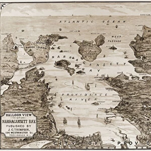
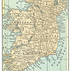
Fine Art Print : Rhode Island map 1877


![]()
Fine Art Prints from Fine Art Storehouse
Rhode Island map 1877
Warrens Common School Geography 1877
Unleash your creativity and transform your space into a visual masterpiece!
THEPALMER
Media ID 14824567
© This content is subject to copyright
Connecticut Kent Massachusetts Rhode Island Newport Providence Richmond
20"x16" (+3" Border) Fine Art Print
Step back in time with this exquisite Rhode Island map print from ThePalmer, available in the Media Storehouse Fine Art Prints collection. Originally published in 1877 as part of the Warren's Common School Geography, this vintage map offers a captivating glimpse into the history and geography of Rhode Island over a century ago. The intricate details and rich colors bring the past to life, making this print an elegant addition to any home or office space. Perfect for history enthusiasts, educators, or anyone looking to add a touch of nostalgia to their decor. Order your Rhode Island map print from Media Storehouse Fine Art Prints today and let the stories of the past unfold in your home.
20x16 image printed on 26x22 Fine Art Rag Paper with 3" (76mm) white border. Our Fine Art Prints are printed on 300gsm 100% acid free, PH neutral paper with archival properties. This printing method is used by museums and art collections to exhibit photographs and art reproductions.
Our fine art prints are high-quality prints made using a paper called Photo Rag. This 100% cotton rag fibre paper is known for its exceptional image sharpness, rich colors, and high level of detail, making it a popular choice for professional photographers and artists. Photo rag paper is our clear recommendation for a fine art paper print. If you can afford to spend more on a higher quality paper, then Photo Rag is our clear recommendation for a fine art paper print.
Estimated Image Size (if not cropped) is 40.6cm x 50.8cm (16" x 20")
Estimated Product Size is 55.9cm x 66cm (22" x 26")
These are individually made so all sizes are approximate
Artwork printed orientated as per the preview above, with portrait (vertical) orientation to match the source image.
FEATURES IN THESE COLLECTIONS
> Europe
> United Kingdom
> Wales
> Gwent
> Newport
> Europe
> United Kingdom
> Wales
> Pembrokeshire
> Newport
> Maps and Charts
> Related Images
> North America
> United States of America
> Connecticut
> Related Images
> North America
> United States of America
> Maps
> North America
> United States of America
> Massachusetts
> Related Images
> North America
> United States of America
> Rhode Island
> Providence
> North America
> United States of America
> Rhode Island
> Related Images
> Fine Art Storehouse
> Map
> Historical Maps
> Fine Art Storehouse
> Map
> USA Maps
EDITORS COMMENTS
In this print titled "Rhode Island map 1877" we are transported back to a significant moment in history. The image showcases an intricately detailed map, extracted from the renowned Warrens Common School Geography of 1877. This vintage piece offers us a glimpse into the past, specifically focusing on the states of Connecticut and Rhode Island within the United States. The artist behind this remarkable creation, known as THEPALMER, has masterfully captured every intricate detail of this historical artifact. From Kent to Massachusetts, Newport to Providence, Richmond to countless other locations marked with precision - it is evident that great care was taken in preserving and presenting this piece. As we immerse ourselves in its rich colors and delicate lines, we cannot help but appreciate how maps have always been essential tools for exploration and understanding our world. They serve as gateways to discovery - guiding us through unknown territories while simultaneously revealing stories of human civilization. This particular print serves as a testament to Rhode Island's unique geography and its place within American history. It invites viewers to reflect upon the state's cultural heritage while igniting curiosity about its evolution over time. "The Rhode Island map 1877" by THEPALMER is not just a beautiful work of art; it is also an invitation for us all to delve into our collective past and appreciate the beauty found within historical cartography.
MADE IN AUSTRALIA
Safe Shipping with 30 Day Money Back Guarantee
FREE PERSONALISATION*
We are proud to offer a range of customisation features including Personalised Captions, Color Filters and Picture Zoom Tools
SECURE PAYMENTS
We happily accept a wide range of payment options so you can pay for the things you need in the way that is most convenient for you
* Options may vary by product and licensing agreement. Zoomed Pictures can be adjusted in the Cart.