Fine Art Print > North America > United States of America > New York > New York > Maps
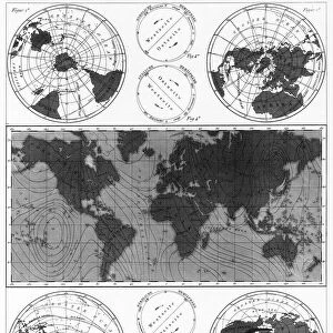
Fine Art Print : Weather map of United States 1895


![]()
Fine Art Prints from Fine Art Storehouse
Weather map of United States 1895
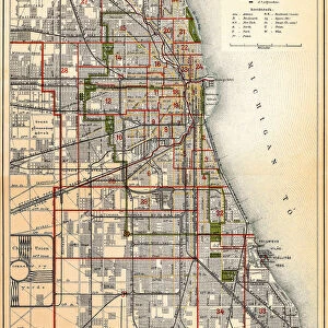
The Rand-McNally Grammar School Geography 1895 - Chicago & New York
Unleash your creativity and transform your space into a visual masterpiece!
THEPALMER
Media ID 14824623
© This content is subject to copyright
Atlantic Ocean Canada Currents North America Rain United States Weather Winds
20"x16" (+3" Border) Fine Art Print
Step back in time with our exquisite Weather Map of the United States from 1895 by THEPALMER, available in our Fine Art Prints collection at Media Storehouse. This captivating vintage weather map, originally published in The Rand-McNally Grammar School Geography of 1895 from Chicago & New York, showcases the meticulous detail and intricate design of weather maps from a bygone era. Bring a touch of history and nostalgia to your home or office decor with this stunning fine art print, perfect for weather enthusiasts, history buffs, or anyone who appreciates the beauty of vintage cartography.
20x16 image printed on 26x22 Fine Art Rag Paper with 3" (76mm) white border. Our Fine Art Prints are printed on 300gsm 100% acid free, PH neutral paper with archival properties. This printing method is used by museums and art collections to exhibit photographs and art reproductions.
Our fine art prints are high-quality prints made using a paper called Photo Rag. This 100% cotton rag fibre paper is known for its exceptional image sharpness, rich colors, and high level of detail, making it a popular choice for professional photographers and artists. Photo rag paper is our clear recommendation for a fine art paper print. If you can afford to spend more on a higher quality paper, then Photo Rag is our clear recommendation for a fine art paper print.
Estimated Image Size (if not cropped) is 50.8cm x 40.6cm (20" x 16")
Estimated Product Size is 66cm x 55.9cm (26" x 22")
These are individually made so all sizes are approximate
Artwork printed orientated as per the preview above, with landscape (horizontal) orientation to match the source image.
FEATURES IN THESE COLLECTIONS
> Arts
> Artists
> O
> Oceanic Oceanic
> Maps and Charts
> Related Images
> North America
> Canada
> Maps
> North America
> Canada
> Related Images
> North America
> Related Images
> North America
> United States of America
> Maps
> North America
> United States of America
> New York
> New York
> Maps
> North America
> United States of America
> New York
> Related Images
> Fine Art Storehouse
> Map
> Historical Maps
> Fine Art Storehouse
> Map
> USA Maps
EDITORS COMMENTS
In this print titled "Weather map of United States 1895" we are transported back in time to a bygone era where the art of cartography and meteorology converged. The image, sourced from "The Rand-McNally Grammar School Geography 1895" publication, showcases an intricately detailed weather map that once adorned classrooms across Chicago and New York. As our eyes wander over the vast expanse of this vintage masterpiece, we are immediately drawn to the rich tapestry of information it presents. From the majestic Atlantic Ocean stretching out towards Canada, to the intricate depiction of wind patterns and ocean currents, every element on this map tells a story about nature's ever-changing moods. This historical gem not only serves as a visual delight but also offers valuable insights into how weather forecasting was approached over a century ago. It reminds us of the relentless pursuit humans have had in understanding their environment and predicting its whimsical behavior. "The Weather Map of United States 1895" is more than just an artistic representation; it encapsulates both scientific knowledge and aesthetic beauty. Its presence on any wall would undoubtedly spark curiosity and ignite conversations about our planet's dynamic climate systems. THEPALMER has masterfully captured this piece with great attention to detail, preserving its authenticity for generations to come. As we admire this remarkable artwork today, let us appreciate how far we have come in unraveling nature's mysteries while cherishing these timeless relics that connect us with our past.
MADE IN AUSTRALIA
Safe Shipping with 30 Day Money Back Guarantee
FREE PERSONALISATION*
We are proud to offer a range of customisation features including Personalised Captions, Color Filters and Picture Zoom Tools
SECURE PAYMENTS
We happily accept a wide range of payment options so you can pay for the things you need in the way that is most convenient for you
* Options may vary by product and licensing agreement. Zoomed Pictures can be adjusted in the Cart.