Fine Art Print > North America > United States of America > New York > New York > Maps
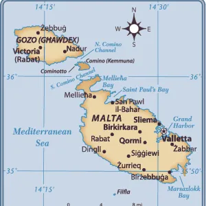
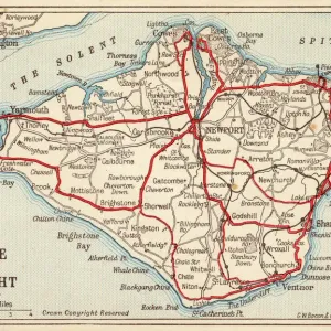
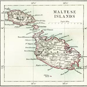
Fine Art Print : Maltese islands map 1883


![]()
Fine Art Prints from Fine Art Storehouse
Maltese islands map 1883
Encyclopedia Britannica 9th Edition New York Samuel L. Hall 1883 Vol XV
Unleash your creativity and transform your space into a visual masterpiece!
THEPALMER
Media ID 14713795
© This content is subject to copyright
20"x20" (+3" Border) Fine Art Print
Discover the rich history of the Maltese islands with this exquisite Fine Art Print from Media Storehouse. This captivating map, titled "Maltese Islands" and dated 1883, is an original reproduction from the Encyclopedia Britannica 9th Edition, New York, published by Samuel L. Hall. The intricate details of this vintage map, created by THEPALMER, beautifully illustrate the islands' geography and historical significance during that era. Bring a piece of history into your home or office with this stunning Fine Art Print, perfect for those who appreciate the beauty of cartography and the cultural heritage of the Maltese islands.
20x20 image printed on 26x26 Fine Art Rag Paper with 3" (76mm) white border. Our Fine Art Prints are printed on 300gsm 100% acid free, PH neutral paper with archival properties. This printing method is used by museums and art collections to exhibit photographs and art reproductions.
Our fine art prints are high-quality prints made using a paper called Photo Rag. This 100% cotton rag fibre paper is known for its exceptional image sharpness, rich colors, and high level of detail, making it a popular choice for professional photographers and artists. Photo rag paper is our clear recommendation for a fine art paper print. If you can afford to spend more on a higher quality paper, then Photo Rag is our clear recommendation for a fine art paper print.
Estimated Image Size (if not cropped) is 50.8cm x 50.8cm (20" x 20")
Estimated Product Size is 66cm x 66cm (26" x 26")
These are individually made so all sizes are approximate
Artwork printed orientated as per the preview above, with landscape (horizontal) or portrait (vertical) orientation to match the source image.
FEATURES IN THESE COLLECTIONS
> Europe
> Malta
> Related Images
> Maps and Charts
> Malta
> Maps and Charts
> Related Images
> North America
> United States of America
> New York
> New York
> Maps
> North America
> United States of America
> New York
> Related Images
> Fine Art Storehouse
> Map
> Historical Maps
> Fine Art Storehouse
> Top Sellers - Art Prints
> Fine Art Storehouse
> Travel Imagery
> Travel Destinations
> Malta Through Time
EDITORS COMMENTS
This print showcases a rare gem from the past, a meticulously detailed map of the Maltese islands dating back to 1883. Taken from the esteemed Encyclopedia Britannica 9th Edition, New York publication by Samuel L. Hall, this vintage piece offers a fascinating glimpse into the historical cartography of Malta and its surrounding regions. The intricate lines and delicate shading on this map beautifully depict Gozo, Malta, Valetta, and other significant locations within these enchanting Mediterranean isles. Every curve and contour tells a story of centuries-old civilizations that have left their mark on this archipelago. Expertly captured by THEPALMER for Fine Art Storehouse, this print transports us back in time to an era when exploration was at its peak. The attention to detail in every inch of this artwork is truly mesmerizing; it invites viewers to immerse themselves in the rich history and cultural heritage of these stunning islands. Whether you are an avid collector or simply appreciate the beauty of antique maps, this exquisite print will undoubtedly become a cherished addition to any space. Let your imagination wander as you trace ancient trade routes or envision yourself strolling through bustling streets frozen in time. Embrace nostalgia with "Maltese Islands Map 1883" - an extraordinary piece that captures both artistry and history within its carefully preserved contours.
MADE IN AUSTRALIA
Safe Shipping with 30 Day Money Back Guarantee
FREE PERSONALISATION*
We are proud to offer a range of customisation features including Personalised Captions, Color Filters and Picture Zoom Tools
SECURE PAYMENTS
We happily accept a wide range of payment options so you can pay for the things you need in the way that is most convenient for you
* Options may vary by product and licensing agreement. Zoomed Pictures can be adjusted in the Cart.