Fine Art Print > North America > United States of America > New York > New York > Maps
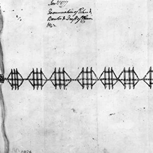
Fine Art Print : Map of Stony Point and Verplancks Point on the Hudson River, held and fortified by the British from late May 1779 till they were captured by American troops led by Anthony Wayne, 16 July 1779. Wood engraving, American, 1852


![]()
Fine Art Prints from Granger
Map of Stony Point and Verplancks Point on the Hudson River, held and fortified by the British from late May 1779 till they were captured by American troops led by Anthony Wayne, 16 July 1779. Wood engraving, American, 1852
STONY POINT MAP, 1779.
Map of Stony Point and Verplancks Point on the Hudson River, held and fortified by the British from late May 1779 till they were captured by American troops led by Anthony Wayne, 16 July 1779. Wood engraving, American, 1852
Granger holds millions of images spanning more than 25,000 years of world history, from before the Stone Age to the dawn of the Space Age
Media ID 7964139
1779 American Revolution Anthony British Fort Fortification Garrison Hudson River New York State Plan Revolutionary War Stony Point United States Wayne
21"x14" (+3" Border) Fine Art Print
Step back in time with our exquisite Fine Art Print of the Stony Point and Verplancks Point Map from 1779. This intricately detailed wood engraving, created by The Granger Collection in 1852, depicts the strategic Hudson River area held and fortified by the British from late May 1779 until their capture by American troops under the command of Anthony Wayne on July 16, 1779. Add this historical masterpiece to your collection and bring a piece of American Revolutionary War history into your home or office.
21x14 image printed on 27x20 Fine Art Rag Paper with 3" (76mm) white border. Our Fine Art Prints are printed on 300gsm 100% acid free, PH neutral paper with archival properties. This printing method is used by museums and art collections to exhibit photographs and art reproductions.
Our fine art prints are high-quality prints made using a paper called Photo Rag. This 100% cotton rag fibre paper is known for its exceptional image sharpness, rich colors, and high level of detail, making it a popular choice for professional photographers and artists. Photo rag paper is our clear recommendation for a fine art paper print. If you can afford to spend more on a higher quality paper, then Photo Rag is our clear recommendation for a fine art paper print.
Estimated Image Size (if not cropped) is 53.3cm x 30.2cm (21" x 11.9")
Estimated Product Size is 68.6cm x 50.8cm (27" x 20")
These are individually made so all sizes are approximate
Artwork printed orientated as per the preview above, with landscape (horizontal) orientation to match the source image.
FEATURES IN THESE COLLECTIONS
> Maps and Charts
> Related Images
> North America
> Related Images
> North America
> United States of America
> New York
> New York
> Maps
> North America
> United States of America
> New York
> Related Images
> Granger Art on Demand
> American Revolution
> Granger Art on Demand
> Plans and Diagrams
EDITORS COMMENTS
This wood engraving from 1852 depicts a significant moment in American history - the capture of Stony Point and Verplancks Point on the Hudson River during the Revolutionary War. The British had held and fortified these strategic locations since late May 1779, but their reign came to an end on July 16th of that year when American troops, led by the brave Anthony Wayne, successfully seized control. The intricately detailed map showcases the layout of both forts and highlights their importance in controlling access along the Hudson River. It serves as a visual representation of the determination and bravery displayed by American soldiers during this pivotal time. As we gaze upon this historical print, we are transported back to a time when our nation fought for its independence. We can almost hear the sounds of battle echoing through those hillsides, feel the tension in the air as soldiers strategized their next move. This image is not just a piece of art; it is a window into our past, reminding us of those who sacrificed so much for our freedom. Displayed proudly within Granger Art's Carousel Collection, this wood engraving stands as a testament to America's resilience and unwavering spirit throughout history. It serves as an educational tool for future generations to learn about one chapter in our nation's journey towards liberty.
MADE IN AUSTRALIA
Safe Shipping with 30 Day Money Back Guarantee
FREE PERSONALISATION*
We are proud to offer a range of customisation features including Personalised Captions, Color Filters and Picture Zoom Tools
FREE COLORIZATION SERVICE
You can choose advanced AI Colorization for this picture at no extra charge!
SECURE PAYMENTS
We happily accept a wide range of payment options so you can pay for the things you need in the way that is most convenient for you
* Options may vary by product and licensing agreement. Zoomed Pictures can be adjusted in the Cart.