Fine Art Print > Maps and Charts > Related Images
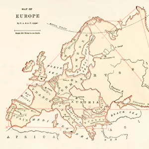
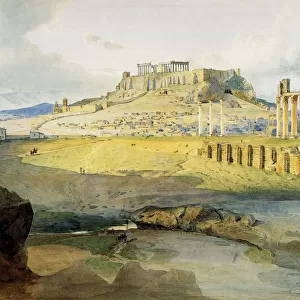
Fine Art Print : Map of Europe showing how it appeared at the time of the Accession of The Emperor Charles V in AD 1519


![]()
Fine Art Prints from MapSeeker
Map of Europe showing how it appeared at the time of the Accession of The Emperor Charles V in AD 1519
EHIST008
Welcome to the Mapseeker Image library and enter an historic gateway to one of the largest on-line collections of Historic Maps, Nostalgic Views, Vista's and Panorama's from a World gone by.
Media ID 20348250
Europe Europe Map Map Of Europe
20"x16" (+3" Border) Fine Art Print
Step back in time with our exquisite Fine Art Print from Media Storehouse, featuring a captivating Map of Europe as it appeared during the momentous year of 1519. This intricately detailed map, sourced from MapSeeker, marks the accession of Emperor Charles V. Each print is meticulously crafted using high-quality materials and techniques to bring the historical cartography to life. Add a touch of history and artistry to your space, and transport yourself back to an era of exploration and discovery with this stunning addition to your collection.
20x16 image printed on 26x22 Fine Art Rag Paper with 3" (76mm) white border. Our Fine Art Prints are printed on 300gsm 100% acid free, PH neutral paper with archival properties. This printing method is used by museums and art collections to exhibit photographs and art reproductions.
Our fine art prints are high-quality prints made using a paper called Photo Rag. This 100% cotton rag fibre paper is known for its exceptional image sharpness, rich colors, and high level of detail, making it a popular choice for professional photographers and artists. Photo rag paper is our clear recommendation for a fine art paper print. If you can afford to spend more on a higher quality paper, then Photo Rag is our clear recommendation for a fine art paper print.
Estimated Image Size (if not cropped) is 48.7cm x 40.6cm (19.2" x 16")
Estimated Product Size is 66cm x 55.9cm (26" x 22")
These are individually made so all sizes are approximate
Artwork printed orientated as per the preview above, with landscape (horizontal) orientation to match the source image.
FEATURES IN THESE COLLECTIONS
> Maps and Charts
> Related Images
> MapSeeker
> Maps of Europe
> Old Maps of Europe and Small Islands of
EDITORS COMMENTS
This print showcases a historical treasure, the "Map of Europe showing how it appeared at the time of the Accession of The Emperor Charles V in AD 1519". This meticulously crafted map offers us a glimpse into the political landscape and geographical boundaries that shaped Europe during this significant period. As we gaze upon this remarkable piece, our eyes are immediately drawn to the intricate details and vibrant colors that bring each nation to life. From Spain's vast empire stretching across continents to France's regal presence in Western Europe, every kingdom is depicted with precision and artistry. The map not only highlights major cities but also captures rivers, mountain ranges, and other natural features that influenced strategic decisions and trade routes. The accession of Emperor Charles V in 1519 marked a turning point in European history. His reign witnessed profound changes as he inherited an extensive empire comprising territories from Spain, Austria, Italy, Germany, and more. This map allows us to comprehend the sheer magnitude of his dominion while appreciating the diverse cultures and languages encompassed within its borders. Beyond its historical significance lies an aesthetic appeal that draws viewers closer. Its vintage charm evokes nostalgia for a bygone era when cartography was both science and art. Whether displayed in classrooms or personal collections, this print serves as a window into Europe's past—a tangible reminder of how empires rose and fell amidst ever-shifting alliances on this ancient continent
MADE IN AUSTRALIA
Safe Shipping with 30 Day Money Back Guarantee
FREE PERSONALISATION*
We are proud to offer a range of customisation features including Personalised Captions, Color Filters and Picture Zoom Tools
SECURE PAYMENTS
We happily accept a wide range of payment options so you can pay for the things you need in the way that is most convenient for you
* Options may vary by product and licensing agreement. Zoomed Pictures can be adjusted in the Cart.