Fine Art Print > Maps and Charts > Related Images
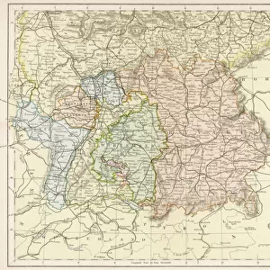
Fine Art Print : Map of Europe showing how it appeared in the time of Charles the Great AD 768 - AD 814


![]()
Fine Art Prints from MapSeeker
Map of Europe showing how it appeared in the time of Charles the Great AD 768 - AD 814
EHIST004
Welcome to the Mapseeker Image library and enter an historic gateway to one of the largest on-line collections of Historic Maps, Nostalgic Views, Vista's and Panorama's from a World gone by.
Media ID 20348266
Europe Europe Map Map Of Europe
20"x16" (+3" Border) Fine Art Print
Step back in time with our exquisite Fine Art Print from Media Storehouse, featuring a captivating Map of Europe as it appeared during the reign of Charles the Great, also known as Charlemagne, from AD 768 to AD 814. This intricately detailed map, sourced from MapSeeker, transports you back to the early Middle Ages, showcasing the political landscape of Europe during one of its most influential eras. Bring history to life in your home or office with this stunning piece of art, perfect for history enthusiasts, educators, or anyone with an appreciation for the rich tapestry of our past.
20x16 image printed on 26x22 Fine Art Rag Paper with 3" (76mm) white border. Our Fine Art Prints are printed on 300gsm 100% acid free, PH neutral paper with archival properties. This printing method is used by museums and art collections to exhibit photographs and art reproductions.
Our fine art prints are high-quality prints made using a paper called Photo Rag. This 100% cotton rag fibre paper is known for its exceptional image sharpness, rich colors, and high level of detail, making it a popular choice for professional photographers and artists. Photo rag paper is our clear recommendation for a fine art paper print. If you can afford to spend more on a higher quality paper, then Photo Rag is our clear recommendation for a fine art paper print.
Estimated Image Size (if not cropped) is 48.7cm x 40.6cm (19.2" x 16")
Estimated Product Size is 66cm x 55.9cm (26" x 22")
These are individually made so all sizes are approximate
Artwork printed orientated as per the preview above, with landscape (horizontal) orientation to match the source image.
FEATURES IN THESE COLLECTIONS
> Maps and Charts
> Related Images
> MapSeeker
> Maps of Europe
> Old Maps of Europe and Small Islands of
EDITORS COMMENTS
This print showcases a historically significant artifact, the "Map of Europe showing how it appeared in the time of Charles the Great AD 768 - AD 814". This meticulously crafted map offers a glimpse into the European landscape during an era that shaped its destiny. Created by MapSeeker, this reproduction allows us to appreciate and study one of history's most influential periods. The map takes us back to the reign of Charles the Great, also known as Charlemagne, who ruled over vast territories from his coronation in 768 until his death in 814. As we examine this visual representation, we are transported to a time when empires were forged and borders were redrawn. The intricate details on this print provide valuable insights into political divisions, major cities, and geographical features that characterized Europe during this transformative period. Through studying this map print with curiosity and fascination, we can trace Charlemagne's expansive empire stretching across modern-day France, Germany, Italy, Spain, and beyond. It highlights key regions such as Lombardy, Bavaria, Aquitaine—each playing a crucial role in shaping medieval Europe's socio-political fabric. MapSeeker has expertly reproduced this historical gem for educational purposes only; it is not intended for commercial use. By preserving and sharing these artifacts through photography prints like these ones from MapSeeker ensures that future generations can delve into our rich past and gain deeper understanding about our shared heritage.
MADE IN AUSTRALIA
Safe Shipping with 30 Day Money Back Guarantee
FREE PERSONALISATION*
We are proud to offer a range of customisation features including Personalised Captions, Color Filters and Picture Zoom Tools
SECURE PAYMENTS
We happily accept a wide range of payment options so you can pay for the things you need in the way that is most convenient for you
* Options may vary by product and licensing agreement. Zoomed Pictures can be adjusted in the Cart.