Fine Art Print > Europe > Netherlands > Maps
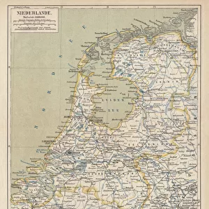
Fine Art Print : Map / France / Belgium / Nethe


![]()
Fine Art Prints from Mary Evans Picture Library
Map / France / Belgium / Nethe
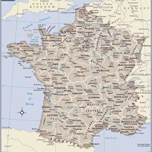
Map of France, Belgium and the Netherlands
Mary Evans Picture Library makes available wonderful images created for people to enjoy over the centuries
Media ID 608787
© Mary Evans Picture Library 2015 - https://copyrighthub.org/s0/hub1/creation/maryevans/MaryEvansPictureID/10113948
20"x16" (+3" Border) Fine Art Print
Discover the rich history and cultural connections of Europe with our exquisite Fine Art Prints from the Media Storehouse collection. This stunning piece, "Map / France / Belgium / Nethe" by Mary Evans Picture Library from Mary Evans Prints Online, showcases an intricately detailed map of France, Belgium, and the Netherlands. Transport yourself back in time as you explore the borders and territories of these historic European nations. Each print is meticulously crafted using high-quality materials and vibrant colors, ensuring a beautiful addition to any home or office space. Elevate your decor and ignite your curiosity with this captivating work of art.
20x16 image printed on 26x22 Fine Art Rag Paper with 3" (76mm) white border. Our Fine Art Prints are printed on 300gsm 100% acid free, PH neutral paper with archival properties. This printing method is used by museums and art collections to exhibit photographs and art reproductions.
Our fine art prints are high-quality prints made using a paper called Photo Rag. This 100% cotton rag fibre paper is known for its exceptional image sharpness, rich colors, and high level of detail, making it a popular choice for professional photographers and artists. Photo rag paper is our clear recommendation for a fine art paper print. If you can afford to spend more on a higher quality paper, then Photo Rag is our clear recommendation for a fine art paper print.
Estimated Image Size (if not cropped) is 40.6cm x 50.8cm (16" x 20")
Estimated Product Size is 55.9cm x 66cm (22" x 26")
These are individually made so all sizes are approximate
Artwork printed orientated as per the preview above, with portrait (vertical) orientation to match the source image.
FEATURES IN THESE COLLECTIONS
> Europe
> Belgium
> Related Images
> Europe
> Netherlands
> Maps
> Europe
> Netherlands
> Posters
> Europe
> Netherlands
> Related Images
> Europe
> Related Images
> Maps and Charts
> Early Maps
EDITORS COMMENTS
This early 20th century map print depicts the territories of France, Belgium, and the Netherlands in Europe. The intricate details of the map show the political boundaries of these countries during a significant period in European history. France, located in the western part of the map, is shown in its full extent, including its metropolitan regions and overseas territories. The map highlights the major cities of France, such as Paris, Marseille, Bordeaux, and Lyon, as well as significant geographical features like the Alps, the Massif Central, and the Rhine River. To the north of France lies Belgium, a small but historically important country. The map reveals the division of Belgium into its three regions: Flanders in the north, Wallonia in the south, and Brussels, the capital city, in the center. The map also shows the major rivers of Belgium, including the Meuse, the Scheldt, and the Rhine. The Netherlands, located to the northeast of Belgium, is shown in its full extent, including the provinces of North and South Holland, Zeeland, and Friesland. The map highlights the major cities of the Netherlands, such as Amsterdam, Rotterdam, and The Hague, as well as significant geographical features like the North Sea, the Rhine River, and the Wadden Sea. This map offers a fascinating glimpse into the political and geographical landscape of Europe during the early 20th century, a time of significant change and development in the history of France, Belgium, and the Netherlands. The intricate details of the map provide valuable insights into the historical context of this region and offer a visual representation of the complex interconnections between these countries and their shared history.
MADE IN AUSTRALIA
Safe Shipping with 30 Day Money Back Guarantee
FREE PERSONALISATION*
We are proud to offer a range of customisation features including Personalised Captions, Color Filters and Picture Zoom Tools
SECURE PAYMENTS
We happily accept a wide range of payment options so you can pay for the things you need in the way that is most convenient for you
* Options may vary by product and licensing agreement. Zoomed Pictures can be adjusted in the Cart.