Fine Art Print > Europe > Norway > Maps
Fine Art Print : Map of Spitsbergen, Norway


![]()
Fine Art Prints from Mary Evans Picture Library
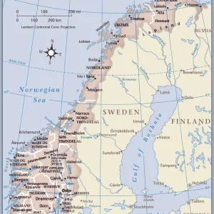
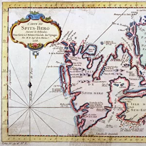
Map of Spitsbergen, Norway
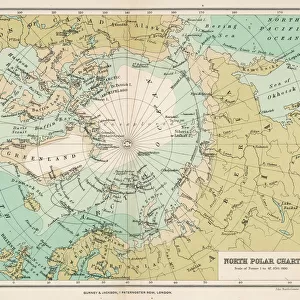
Map of Spitsbergen, Svalbard, Norway Date: 1758
Mary Evans Picture Library makes available wonderful images created for people to enjoy over the centuries
Media ID 14267943
© Mary Evans Picture Library
1758 Maps Nordic Norway Norwegian Spitsbergen Spitzbergen Svalbard
20"x16" (+3" Border) Fine Art Print
Discover the captivating beauty of the Arctic with our exquisite Fine Art Prints from Media Storehouse. This particular piece showcases an intriguing map of Spitsbergen, Norway, dated 1758, sourced from Mary Evans Prints Online. With meticulous attention to detail, this Rights Managed print transports you to the icy landscapes of Svalbard. Ideal for art enthusiasts, collectors, or those seeking to add a touch of history and adventure to their space, this fine art print is a must-have addition to your decor. Bring the wonders of the Arctic into your home or office with Media Storehouse's exceptional range of Fine Art Prints.
20x16 image printed on 26x22 Fine Art Rag Paper with 3" (76mm) white border. Our Fine Art Prints are printed on 300gsm 100% acid free, PH neutral paper with archival properties. This printing method is used by museums and art collections to exhibit photographs and art reproductions.
Our fine art prints are high-quality prints made using a paper called Photo Rag. This 100% cotton rag fibre paper is known for its exceptional image sharpness, rich colors, and high level of detail, making it a popular choice for professional photographers and artists. Photo rag paper is our clear recommendation for a fine art paper print. If you can afford to spend more on a higher quality paper, then Photo Rag is our clear recommendation for a fine art paper print.
Estimated Image Size (if not cropped) is 50.8cm x 36.8cm (20" x 14.5")
Estimated Product Size is 66cm x 55.9cm (26" x 22")
These are individually made so all sizes are approximate
Artwork printed orientated as per the preview above, with landscape (horizontal) orientation to match the source image.
FEATURES IN THESE COLLECTIONS
> Europe
> Norway
> Related Images
> Europe
> Related Images
> Maps and Charts
> Related Images
EDITORS COMMENTS
1. Title: "Exploring the Frozen Frontier: A Glimpse into the 18th Century Cartography of Spitsbergen, Norway" This map print, dated 1758, offers a fascinating glimpse into the cartographic exploration of Spitsbergen, a remote archipelago located in the Arctic Ocean, north of mainland Norway and part of the Svalbard group of islands. The map, produced during the 18th century, is an essential piece of Nordic and Norwegian cartographic history. The intricate details on this map reveal the extensive knowledge that cartographers had acquired about the region up to that point in time. The map includes various islands, bays, and inlets, some of which may have been discovered only recently. The coastlines are delineated with remarkable precision, and the depth soundings provide valuable information for navigators. The map's title, "Carte des Costes Septentrionales de Norvege, ou Spitzberg," translates to "Map of the Northern Coasts of Norway, or Spitsbergen." The map's creator is not explicitly stated, but it is known that such maps were produced by various cartographers and publishers in Europe during the 18th century. The map's historical significance lies in its role as a crucial navigational tool for explorers and traders during the Age of Discovery. The map would have been essential for those venturing into the Arctic waters in search of valuable resources, such as whales, walruses, and furs. The map's accuracy and detail would have helped ensure the safety of these voyages and contributed to the expansion of European knowledge of the Arctic world. Today, this map serves as a testament to the intrepid spirit of exploration and the remarkable advancements in cartography during the 18th century. It is a reminder of the rich history and cultural significance of Spitsbergen and the Arctic region as a whole.
MADE IN AUSTRALIA
Safe Shipping with 30 Day Money Back Guarantee
FREE PERSONALISATION*
We are proud to offer a range of customisation features including Personalised Captions, Color Filters and Picture Zoom Tools
SECURE PAYMENTS
We happily accept a wide range of payment options so you can pay for the things you need in the way that is most convenient for you
* Options may vary by product and licensing agreement. Zoomed Pictures can be adjusted in the Cart.