Fine Art Print > Historic > World War I and II > World War I
Fine Art Print : Middle Europe Map


![]()
Fine Art Prints from Mary Evans Picture Library
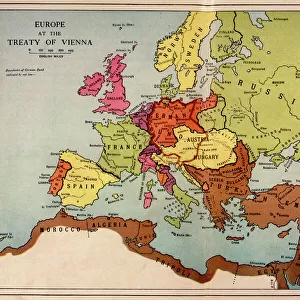
Middle Europe Map
Map of Middle Europe from after the Vienna Congress until the start of World War I (1815 - 1914)
Mary Evans Picture Library makes available wonderful images created for people to enjoy over the centuries
Media ID 623948
© Mary Evans Picture Library 2015 - https://copyrighthub.org/s0/hub1/creation/maryevans/MaryEvansPictureID/10064865
1815 Congress Maps Start Vienna
20"x16" (+3" Border) Fine Art Print
Discover the historical depth of Middle Europe with our exquisite Fine Art Prints from Media Storehouse, featuring the captivating Middle Europe Map by Mary Evans Picture Library/WEIMA. This detailed map, dating from the period between the Vienna Congress and the start of World War I (1815-1914), offers a captivating glimpse into the political landscape of the time. Each print is meticulously reproduced to showcase the intricate details of the map, transporting you back in time. Add a touch of history and sophistication to your home or office with this stunning Fine Art Print from Media Storehouse.
20x16 image printed on 26x22 Fine Art Rag Paper with 3" (76mm) white border. Our Fine Art Prints are printed on 300gsm 100% acid free, PH neutral paper with archival properties. This printing method is used by museums and art collections to exhibit photographs and art reproductions.
Our fine art prints are high-quality prints made using a paper called Photo Rag. This 100% cotton rag fibre paper is known for its exceptional image sharpness, rich colors, and high level of detail, making it a popular choice for professional photographers and artists. Photo rag paper is our clear recommendation for a fine art paper print. If you can afford to spend more on a higher quality paper, then Photo Rag is our clear recommendation for a fine art paper print.
Estimated Image Size (if not cropped) is 49.7cm x 40.6cm (19.6" x 16")
Estimated Product Size is 66cm x 55.9cm (26" x 22")
These are individually made so all sizes are approximate
Artwork printed orientated as per the preview above, with landscape (horizontal) orientation to match the source image.
FEATURES IN THESE COLLECTIONS
> Europe
> Related Images
> Historic
> World War I and II
> World War I
> Maps and Charts
> Early Maps
> Maps and Charts
> Related Images
> Maps and Charts
> World
EDITORS COMMENTS
This stunning print captures the intricate details of a historical map depicting Middle Europe from after the Vienna Congress in 1815 until the start of World War I in 1914. The map showcases the political boundaries, cities, and geographical features of this significant period in European history.
The Vienna Congress was a pivotal event that reshaped Europe following the defeat of Napoleon Bonaparte. It aimed to restore stability and order to the continent after years of war and revolution. This map provides a visual representation of how Middle Europe evolved during this time, showing how borders shifted and nations emerged or disappeared.
From Prussia to Austria-Hungary, this map offers a glimpse into the complex geopolitical landscape that characterized Europe during the 19th century. It serves as a valuable historical resource for understanding the events leading up to World War I, which would ultimately change the course of world history.
Whether you are a history enthusiast or simply appreciate cartography, this print is sure to captivate with its wealth of information and artistic detail. Display it proudly in your home or office as a conversation piece that invites exploration into one of the most transformative periods in European history.
MADE IN AUSTRALIA
Safe Shipping with 30 Day Money Back Guarantee
FREE PERSONALISATION*
We are proud to offer a range of customisation features including Personalised Captions, Color Filters and Picture Zoom Tools
SECURE PAYMENTS
We happily accept a wide range of payment options so you can pay for the things you need in the way that is most convenient for you
* Options may vary by product and licensing agreement. Zoomed Pictures can be adjusted in the Cart.