Fine Art Print > Mary Evans Prints Online > National Archives
Fine Art Print : Canals and rivers of England and Wales


![]()
Fine Art Prints from Mary Evans Picture Library
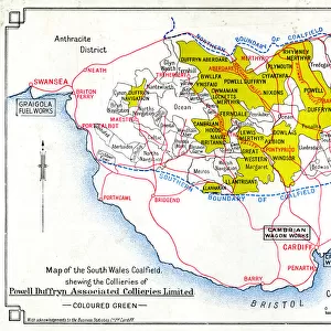
Canals and rivers of England and Wales
Map of canals and navigable rivers of England and Wales, c1910 Date: c. 1910
Mary Evans Picture Library makes available wonderful images created for people to enjoy over the centuries
Media ID 7401937
© Mary Evans Picture Library 2015 - https://copyrighthub.org/s0/hub1/creation/maryevans/MaryEvansPictureID/10474745
20"x16" (+3" Border) Fine Art Print
Discover the timeless beauty of England and Wales with our exquisite selection of Fine Art Prints from Media Storehouse, featuring stunning depictions of canals and navigable rivers. These captivating images, sourced from Mary Evans Prints Online, transport you back in time to an era of tranquil waterways and picturesque landscapes. Each print, dating back to circa 1910, is rights managed, ensuring the highest quality and authenticity. Bring a touch of history and serenity to your home or office with these beautiful, vintage-inspired prints.
20x16 image printed on 26x22 Fine Art Rag Paper with 3" (76mm) white border. Our Fine Art Prints are printed on 300gsm 100% acid free, PH neutral paper with archival properties. This printing method is used by museums and art collections to exhibit photographs and art reproductions.
Our fine art prints are high-quality prints made using a paper called Photo Rag. This 100% cotton rag fibre paper is known for its exceptional image sharpness, rich colors, and high level of detail, making it a popular choice for professional photographers and artists. Photo rag paper is our clear recommendation for a fine art paper print. If you can afford to spend more on a higher quality paper, then Photo Rag is our clear recommendation for a fine art paper print.
Estimated Image Size (if not cropped) is 46.7cm x 40.6cm (18.4" x 16")
Estimated Product Size is 66cm x 55.9cm (26" x 22")
These are individually made so all sizes are approximate
Artwork printed orientated as per the preview above, with landscape (horizontal) orientation to match the source image.
EDITORS COMMENTS
This map print from the early 1910s showcases the extensive network of canals and navigable rivers that crisscrossed England and Wales during the 1900s. The intricate detail of the map reveals the intricate web of waterways that connected various towns and cities, enabling the efficient transportation of goods and people before the widespread use of railways. The map covers a vast area, stretching from the Scottish Borders in the north to the English Channel in the south, and from the Irish Sea in the west to the North Sea in the east. The major rivers, such as the Thames, Severn, and Mersey, are depicted in their entirety, while numerous smaller rivers and canals are also represented. The intricate network of canals, which includes the Grand Union Canal, the Trent and Mersey Canal, and the Leeds and Liverpool Canal, is particularly noteworthy. These man-made waterways allowed for the transportation of coal, iron, and other heavy goods over long distances, contributing significantly to the industrial growth of the region. The map also reveals the rich history of the waterways, with various towns and cities marked, as well as important landmarks and points of interest. The intricate detail of the map is a testament to the extensive planning and engineering that went into creating and maintaining the network of canals and rivers that once formed the backbone of transportation in England and Wales. This map is a fascinating snapshot of a bygone era, offering a unique perspective on the history of transportation in England and Wales during the early 1900s. It is a must-have for anyone with an interest in history, geography, or the industrial heritage of the region.
MADE IN AUSTRALIA
Safe Shipping with 30 Day Money Back Guarantee
FREE PERSONALISATION*
We are proud to offer a range of customisation features including Personalised Captions, Color Filters and Picture Zoom Tools
SECURE PAYMENTS
We happily accept a wide range of payment options so you can pay for the things you need in the way that is most convenient for you
* Options may vary by product and licensing agreement. Zoomed Pictures can be adjusted in the Cart.