Fine Art Print > Maps and Charts > British Empire Maps
Fine Art Print : Map of the British Empire


![]()
Fine Art Prints from Mary Evans Picture Library
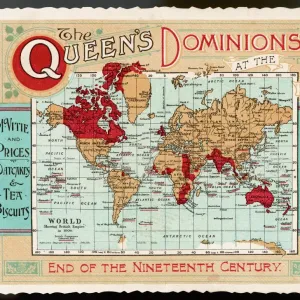
Map of the British Empire
The Howard Vincent map of the British Empire, 1897 Date: 1897
Mary Evans Picture Library makes available wonderful images created for people to enjoy over the centuries
Media ID 7403911
© Mary Evans Picture Library 2015 - https://copyrighthub.org/s0/hub1/creation/maryevans/MaryEvansPictureID/10474598
20"x16" (+3" Border) Fine Art Print
Discover the rich history of the British Empire with our exquisite fine art print from Media Storehouse, featuring the iconic Howard Vincent Map of the British Empire from Mary Evans Prints Online. Dated 1897, this detailed and captivating map offers a glimpse into the extent of the British Empire at the height of its power. Perfect for history enthusiasts, collectors, or those looking to add a touch of nostalgia to their home or office decor. Our fine art prints are carefully produced using high-quality materials and printing techniques to ensure a stunning and long-lasting display. Bring a piece of historical significance into your space with this impressive and intricately detailed map.
20x16 image printed on 26x22 Fine Art Rag Paper with 3" (76mm) white border. Our Fine Art Prints are printed on 300gsm 100% acid free, PH neutral paper with archival properties. This printing method is used by museums and art collections to exhibit photographs and art reproductions.
Our fine art prints are high-quality prints made using a paper called Photo Rag. This 100% cotton rag fibre paper is known for its exceptional image sharpness, rich colors, and high level of detail, making it a popular choice for professional photographers and artists. Photo rag paper is our clear recommendation for a fine art paper print. If you can afford to spend more on a higher quality paper, then Photo Rag is our clear recommendation for a fine art paper print.
Estimated Image Size (if not cropped) is 46.4cm x 40.6cm (18.3" x 16")
Estimated Product Size is 66cm x 55.9cm (26" x 22")
These are individually made so all sizes are approximate
Artwork printed orientated as per the preview above, with landscape (horizontal) orientation to match the source image.
FEATURES IN THESE COLLECTIONS
> Maps and Charts
> British Empire Maps
> Maps and Charts
> Related Images
> Maps and Charts
> World
> Popular Themes
> Maps and Charts
> Mary Evans Prints Online
> National Archives
EDITORS COMMENTS
1. Title: "The Reach of the British Empire: A Glimpse into the 19th Century's Global Power Dynamics through the Howard Vincent Map of 1897" This image presents the Howard Vincent Map of the British Empire, a testament to the vast territorial expansion and influence of the British Empire during the 19th century. Dated 1897, this map offers a striking visual representation of the world as it was then known, with the British Empire's dominion stretching across continents and oceans. The intricate details of this map reveal the extensive reach of the British Empire, which had grown significantly during the Victorian era through a combination of colonization, diplomacy, and military conquest. The map includes annotations detailing the various territories under British rule, from the self-governing dominions like Canada and Australia to the protectorates and colonies scattered across Africa, Asia, and the Pacific. The Howard Vincent Map of the British Empire is an essential historical document, providing valuable insights into the geopolitical landscape of the late 19th century. It serves as a reminder of the profound impact the British Empire had on the world during this period, shaping the political, economic, and cultural landscape in numerous ways. This map also offers a fascinating perspective on the global power dynamics of the time, with the British Empire standing as a dominant force alongside other major European powers. The intricate plan of territories, borders, and annotations on this map offers a glimpse into the complex web of international relations that characterized the late 19th century. In summary, this image of the Howard Vincent Map of the British Empire offers a unique window into the world of the late 19th century, revealing the vast territorial reach and global influence of the British Empire during this transformative era.
MADE IN AUSTRALIA
Safe Shipping with 30 Day Money Back Guarantee
FREE PERSONALISATION*
We are proud to offer a range of customisation features including Personalised Captions, Color Filters and Picture Zoom Tools
SECURE PAYMENTS
We happily accept a wide range of payment options so you can pay for the things you need in the way that is most convenient for you
* Options may vary by product and licensing agreement. Zoomed Pictures can be adjusted in the Cart.