Fine Art Print > Popular Themes > Railway Posters
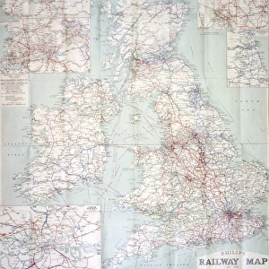
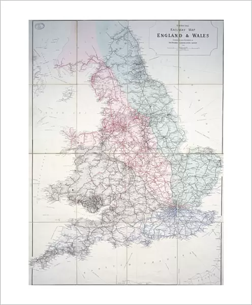
Fine Art Print : Railway map of Britain


![]()
Fine Art Prints from Mary Evans Picture Library
Railway map of Britain
1920 Historical map
Mary Evans Picture Library makes available wonderful images created for people to enjoy over the centuries
Media ID 7401939
© Mary Evans Picture Library 2015 - https://copyrighthub.org/s0/hub1/creation/maryevans/MaryEvansPictureID/10474747
20"x16" (+3" Border) Fine Art Print
Discover the rich history of British railways with our exquisite Fine Art Prints from Media Storehouse. This captivating piece showcases a historical railway map of Britain, dating back to 1920. Sourced from the extensive archive of Mary Evans Prints Online, this rights managed image offers a fascinating glimpse into the past, perfect for railway enthusiasts, historians, or anyone who appreciates the beauty of vintage maps. Bring a piece of history into your home or office with our high-quality Fine Art Prints, expertly printed on premium paper to ensure vibrant colors and long-lasting durability.
20x16 image printed on 26x22 Fine Art Rag Paper with 3" (76mm) white border. Our Fine Art Prints are printed on 300gsm 100% acid free, PH neutral paper with archival properties. This printing method is used by museums and art collections to exhibit photographs and art reproductions.
Our fine art prints are high-quality prints made using a paper called Photo Rag. This 100% cotton rag fibre paper is known for its exceptional image sharpness, rich colors, and high level of detail, making it a popular choice for professional photographers and artists. Photo rag paper is our clear recommendation for a fine art paper print. If you can afford to spend more on a higher quality paper, then Photo Rag is our clear recommendation for a fine art paper print.
Estimated Image Size (if not cropped) is 37.3cm x 50.8cm (14.7" x 20")
Estimated Product Size is 55.9cm x 66cm (22" x 26")
These are individually made so all sizes are approximate
Artwork printed orientated as per the preview above, with portrait (vertical) orientation to match the source image.
FEATURES IN THESE COLLECTIONS
> Maps and Charts
> Early Maps
> Maps and Charts
> Related Images
> Popular Themes
> Railway Posters
> Mary Evans Prints Online
> National Archives
EDITORS COMMENTS
1. Title: "A Journey Through Time: Exploring the Railway Network of Britain in the 1920s". This historical map print, sourced from Mary Evans Prints Online, showcases the extensive railway network of Britain during the 1920s. Officially produced by the Ministry of Transport in the United Kingdom, this map offers a fascinating glimpse into the transportation infrastructure of the time. The map, featuring the intricate details of the railways that crisscrossed the country, is a testament to the rapid expansion and development of the railway system during the early 20th century. With over 6,900 miles of track covering the length and breadth of Britain, the railways were the backbone of the transportation network, connecting cities, towns, and villages, and facilitating the movement of people and goods. The map's intricate details reveal the various railway lines, stations, and junctions, as well as the names of major cities and towns. The map also highlights the different classes of railway lines, from the main lines that served the major urban areas to the branch lines that connected smaller communities. The 1920s were a period of great change and progress in Britain, and this railway map offers a unique perspective on the transportation landscape of the time. It is a reminder of the importance of railways in shaping the country's infrastructure and connecting its people, and a testament to the ingenuity and vision of those who built and operated the railway system. This beautiful and informative map print is a must-have for history enthusiasts, railway enthusiasts, and anyone interested in the history of transportation in Britain. It is a reminder of the past and a connection to the rich heritage of the railway network that continues to serve the country to this day. Dimensions: 29.7 x 42 cm (A3) Condition: Excellent
MADE IN AUSTRALIA
Safe Shipping with 30 Day Money Back Guarantee
FREE PERSONALISATION*
We are proud to offer a range of customisation features including Personalised Captions, Color Filters and Picture Zoom Tools
SECURE PAYMENTS
We happily accept a wide range of payment options so you can pay for the things you need in the way that is most convenient for you
* Options may vary by product and licensing agreement. Zoomed Pictures can be adjusted in the Cart.