Fine Art Print > Europe > Ukraine > Maps
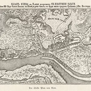
Fine Art Print : Ukraine / Kiev / Old Map 881


![]()
Fine Art Prints from Mary Evans Picture Library
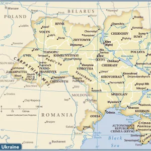
Ukraine / Kiev / Old Map 881
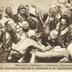
Kiev: the oldest known map
Mary Evans Picture Library makes available wonderful images created for people to enjoy over the centuries
Media ID 578712
© Mary Evans Picture Library 2015 - https://copyrighthub.org/s0/hub1/creation/maryevans/MaryEvansPictureID/10020398
21"x14" (+3" Border) Fine Art Print
Step into the rich history of Ukraine with our exquisite Fine Art Print from Mary Evans Picture Library. Featuring an old map of Kiev, the oldest known record of this historic city, this print is a stunning addition to any home or office. Discover the intricate details and vibrant colors that bring the past to life. Our high-quality Fine Art Prints are carefully produced using archival inks and premium paper, ensuring your print remains a cherished piece for generations to come. Transport yourself to another time and place with this captivating work of art.
21x14 image printed on 27x20 Fine Art Rag Paper with 3" (76mm) white border. Our Fine Art Prints are printed on 300gsm 100% acid free, PH neutral paper with archival properties. This printing method is used by museums and art collections to exhibit photographs and art reproductions.
Our fine art prints are high-quality prints made using a paper called Photo Rag. This 100% cotton rag fibre paper is known for its exceptional image sharpness, rich colors, and high level of detail, making it a popular choice for professional photographers and artists. Photo rag paper is our clear recommendation for a fine art paper print. If you can afford to spend more on a higher quality paper, then Photo Rag is our clear recommendation for a fine art paper print.
Estimated Image Size (if not cropped) is 53.3cm x 28.5cm (21" x 11.2")
Estimated Product Size is 68.6cm x 50.8cm (27" x 20")
These are individually made so all sizes are approximate
Artwork printed orientated as per the preview above, with landscape (horizontal) orientation to match the source image.
FEATURES IN THESE COLLECTIONS
> Europe
> Ukraine
> Related Images
> Maps and Charts
> Early Maps
> Maps and Charts
> Related Images
EDITORS COMMENTS
This stunning print captures a piece of history with "Ukraine / Kiev / Old Map 881" from Mary Evans Picture Library. The map, dating back to 881, is believed to be the oldest known map of Kiev, Ukraine. It offers a fascinating glimpse into the past, showcasing the intricate details and landmarks of this ancient city.
The historical significance of this map cannot be understated, as it provides valuable insights into the layout and development of Kiev over a thousand years ago. From its winding streets to its prominent buildings, every detail on this map tells a story of a bygone era.
As you gaze upon this remarkable piece of cartography, you can't help but feel transported back in time to when Kiev was just beginning to take shape. The craftsmanship and attention to detail that went into creating this map are truly awe-inspiring.
Whether you have a personal connection to Ukraine or simply appreciate history and old maps, "Ukraine / Kiev / Old Map 881" is sure to captivate your imagination. It serves as a reminder of how far we've come as a society while also honoring the rich heritage and culture of this beautiful country.
MADE IN AUSTRALIA
Safe Shipping with 30 Day Money Back Guarantee
FREE PERSONALISATION*
We are proud to offer a range of customisation features including Personalised Captions, Color Filters and Picture Zoom Tools
SECURE PAYMENTS
We happily accept a wide range of payment options so you can pay for the things you need in the way that is most convenient for you
* Options may vary by product and licensing agreement. Zoomed Pictures can be adjusted in the Cart.