Fine Art Print > Arts > Artists > O > Oceanic Oceanic
Fine Art Print : Iceland map, 1800s


![]()
Fine Art Prints from North Wind
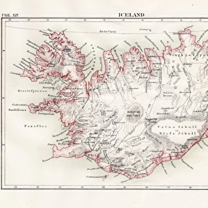
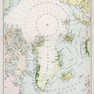
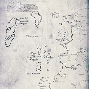
Iceland map, 1800s
Map of Iceland, 1870s.
Printed color lithograph reproduction of a 19th-century illustratioin
North Wind Picture Archives brings history to life with stock images and hand-colored illustrations
Media ID 5882584
© North Wind Picture Archives
Atlantic Atlantic Ocean Island Ocean Fjord North Atlantic
21"x14" (+3" Border) Fine Art Print
Discover the enchanting beauty of Iceland in the 1870s with our exquisite Fine Art Print from Media Storehouse. This captivating reproduction, sourced from the North Wind Picture Archives, showcases an 1800s map of Iceland in stunning detail. The vibrant colors and intricate lines of this lithograph transport you back in time, offering a glimpse into the history and allure of this unique and mysterious land. Bring a piece of the past into your home or office and add a touch of timeless charm to your decor. Order now and let this fine art print tell a story of exploration and discovery.
21x14 image printed on 27x20 Fine Art Rag Paper with 3" (76mm) white border. Our Fine Art Prints are printed on 300gsm 100% acid free, PH neutral paper with archival properties. This printing method is used by museums and art collections to exhibit photographs and art reproductions.
Our fine art prints are high-quality prints made using a paper called Photo Rag. This 100% cotton rag fibre paper is known for its exceptional image sharpness, rich colors, and high level of detail, making it a popular choice for professional photographers and artists. Photo rag paper is our clear recommendation for a fine art paper print. If you can afford to spend more on a higher quality paper, then Photo Rag is our clear recommendation for a fine art paper print.
Estimated Image Size (if not cropped) is 53.3cm x 35.5cm (21" x 14")
Estimated Product Size is 68.6cm x 50.8cm (27" x 20")
These are individually made so all sizes are approximate
Artwork printed orientated as per the preview above, with landscape (horizontal) orientation to match the source image.
FEATURES IN THESE COLLECTIONS
> Arts
> Artists
> O
> Oceanic Oceanic
> Europe
> Iceland
> Related Images
> Maps and Charts
> Related Images
> Popular Themes
> Maps and Charts
> Popular Themes
> North Island
> North Wind Picture Archives
> Maps
EDITORS COMMENTS
This vintage print takes us back to the 19th century, offering a glimpse into Iceland's rich history and natural beauty. The meticulously detailed map showcases the island's unique geography with its jagged coastlines, fjords, and vast stretches of ocean. Printed in vibrant colors using lithography techniques, this reproduction brings to life an illustration that was originally crafted over a century ago. The map not only serves as a visual guide but also evokes a sense of heritage and tradition. It reminds us of Iceland's deep connection to its past and the resilience of its people who have thrived amidst the harsh North Atlantic conditions for centuries. As we explore this artwork, we can almost feel ourselves transported to another time when cartographers painstakingly charted these lands by hand. The artistry displayed in this piece is truly remarkable; it captures both the scientific accuracy required for mapping purposes and an artistic flair that elevates it beyond mere documentation. This fusion of science and art makes it more than just a map – it becomes an exquisite work of historical illustration. Whether you are fascinated by Iceland's history or simply appreciate beautiful artwork from yesteryears, this print offers a window into both worlds. Displaying this piece will undoubtedly spark conversations about exploration, cultural heritage, and the enduring allure of maps as gateways to discovery.
MADE IN AUSTRALIA
Safe Shipping with 30 Day Money Back Guarantee
FREE PERSONALISATION*
We are proud to offer a range of customisation features including Personalised Captions, Color Filters and Picture Zoom Tools
SECURE PAYMENTS
We happily accept a wide range of payment options so you can pay for the things you need in the way that is most convenient for you
* Options may vary by product and licensing agreement. Zoomed Pictures can be adjusted in the Cart.