Fine Art Print > Universal Images Group (UIG) > Art > Archeology
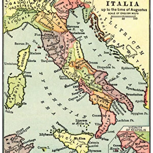
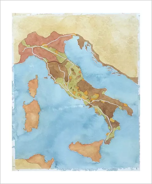
Fine Art Print : Map of Italy illustrates territorial subdivisions at outbreak of Social War, 91 BC, drawing


![]()
Fine Art Prints from Universal Images Group (UIG)
Map of Italy illustrates territorial subdivisions at outbreak of Social War, 91 BC, drawing
Cartography - Roman civilization. Map of Italy illustrates territorial subdivisions at outbreak of Social War, 91 b.C. Color illustration
Universal Images Group (UIG) manages distribution for many leading specialist agencies worldwide
Media ID 9510827
20"x16" (+3" Border) Fine Art Print
Discover the rich history of ancient Rome with our exquisite Fine Art Print from Media Storehouse, featuring a captivating map of Italy from Universal Images Group (UIG). This intricately detailed cartographic representation depicts the territorial subdivisions of Italy at the outbreak of the Social War in 91 BC. A stunning addition to any home or office, this fine art print showcases the cartography of Roman civilization, transporting you back in time. Bring history to life with this beautiful and authentic piece.
20x16 image printed on 26x22 Fine Art Rag Paper with 3" (76mm) white border. Our Fine Art Prints are printed on 300gsm 100% acid free, PH neutral paper with archival properties. This printing method is used by museums and art collections to exhibit photographs and art reproductions.
Our fine art prints are high-quality prints made using a paper called Photo Rag. This 100% cotton rag fibre paper is known for its exceptional image sharpness, rich colors, and high level of detail, making it a popular choice for professional photographers and artists. Photo rag paper is our clear recommendation for a fine art paper print. If you can afford to spend more on a higher quality paper, then Photo Rag is our clear recommendation for a fine art paper print.
Estimated Image Size (if not cropped) is 40.6cm x 50cm (16" x 19.7")
Estimated Product Size is 55.9cm x 66cm (22" x 26")
These are individually made so all sizes are approximate
Artwork printed orientated as per the preview above, with portrait (vertical) orientation to match the source image.
EDITORS COMMENTS
This print takes us back in time to the ancient civilization of Italy during the outbreak of the Social War in 91 BC. The map beautifully illustrates the territorial subdivisions that existed during this tumultuous period, providing a fascinating glimpse into the political landscape of that era. The vertical aerial view allows us to appreciate the intricate details and boundaries depicted on this historical cartographic masterpiece. From Sicily in the south to regions like Rome and beyond, every inch of Italy's geography is meticulously captured, showcasing its diverse landscapes and strategic locations. As we delve into history through this illustration and painting, it becomes evident that no people are present within its frame. Yet, their absence only enhances our curiosity about what life was like during those times - how did these territorial divisions impact society? What were the motivations behind the Social War? The Mediterranean Sea serves as a prominent backdrop, reminding us of Italy's significant maritime influence throughout history. This image transports us to an era long gone but not forgotten; it invites contemplation about our past and how it has shaped our present. It is important to note that this print from Universal Images Group (UIG) should not be used for commercial purposes. Instead, let it serve as a visual portal connecting us with ancient civilizations and igniting our imagination about bygone eras.
MADE IN AUSTRALIA
Safe Shipping with 30 Day Money Back Guarantee
FREE PERSONALISATION*
We are proud to offer a range of customisation features including Personalised Captions, Color Filters and Picture Zoom Tools
SECURE PAYMENTS
We happily accept a wide range of payment options so you can pay for the things you need in the way that is most convenient for you
* Options may vary by product and licensing agreement. Zoomed Pictures can be adjusted in the Cart.