Fine Art Print > Europe > United Kingdom > England > Maps
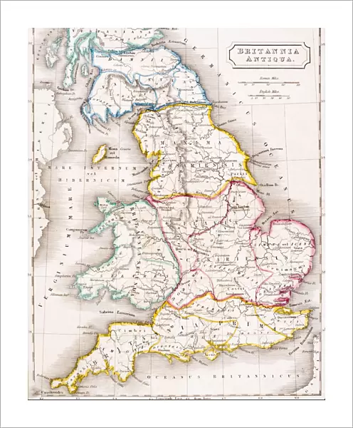
Fine Art Print : Map of England Britannia Antiqua From The Atlas of Ancient Geography by Samuel Butler published London circa 1829


![]()
Fine Art Prints from Universal Images Group (UIG)
Map of England Britannia Antiqua From The Atlas of Ancient Geography by Samuel Butler published London circa 1829
Universal Images Group (UIG) manages distribution for many leading specialist agencies worldwide
Media ID 20165273
© Universal Images Group
Antiquity Britannia Color Colour Welsh Antiqua
20"x16" (+3" Border) Fine Art Print
Step back in time with our exquisite Fine Art Print of the Map of England Britannia Antiqua from The Atlas of Ancient Geography by Samuel Butler. Published in London around 1829, this captivating print showcases England as it appeared during ancient times. The intricate details of the map, brought to you by Universal History Archive/Universal Images Group, make it a stunning addition to any room. Transport yourself to the past with this beautiful and historically significant piece of art.
20x16 image printed on 26x22 Fine Art Rag Paper with 3" (76mm) white border. Our Fine Art Prints are printed on 300gsm 100% acid free, PH neutral paper with archival properties. This printing method is used by museums and art collections to exhibit photographs and art reproductions.
Our fine art prints are high-quality prints made using a paper called Photo Rag. This 100% cotton rag fibre paper is known for its exceptional image sharpness, rich colors, and high level of detail, making it a popular choice for professional photographers and artists. Photo rag paper is our clear recommendation for a fine art paper print. If you can afford to spend more on a higher quality paper, then Photo Rag is our clear recommendation for a fine art paper print.
Estimated Image Size (if not cropped) is 40.6cm x 50.8cm (16" x 20")
Estimated Product Size is 55.9cm x 66cm (22" x 26")
These are individually made so all sizes are approximate
Artwork printed orientated as per the preview above, with portrait (vertical) orientation to match the source image.
FEATURES IN THESE COLLECTIONS
> Europe
> United Kingdom
> England
> Maps
> Maps and Charts
> Early Maps
> Maps and Charts
> Related Images
> Universal Images Group (UIG)
> History
> Historical Maps
EDITORS COMMENTS
This print showcases a remarkable piece of history - the "Map of England Britannia Antiqua" from Samuel Butler's renowned Atlas of Ancient Geography. Published in London around 1829, this colorful map takes us on an enchanting journey through time and space. With its intricate cartography and vibrant hues, this ancient treasure offers a glimpse into the geographical landscape of England during antiquity. Every detail is meticulously depicted, allowing us to explore the historical boundaries and landmarks that shaped this great nation centuries ago. As we gaze upon this mesmerizing artwork, our imagination transports us back to a bygone era. We can almost hear the echoes of Welsh tales whispered across rolling hills and envision bustling Roman settlements along Hadrian's Wall. This map serves as a portal connecting us with the rich tapestry of English heritage. The Universal History Archive/Universal Images Group has beautifully preserved this piece, capturing its essence for generations to come. It reminds us that history is not just confined within dusty books but can be experienced visually through artful representations like these. Whether you are an avid lover of geography or simply fascinated by ancient civilizations, this print invites you to delve into England's past. Let it adorn your walls as a testament to human curiosity and our unending quest for knowledge about our world's intriguing pasts.
MADE IN AUSTRALIA
Safe Shipping with 30 Day Money Back Guarantee
FREE PERSONALISATION*
We are proud to offer a range of customisation features including Personalised Captions, Color Filters and Picture Zoom Tools
SECURE PAYMENTS
We happily accept a wide range of payment options so you can pay for the things you need in the way that is most convenient for you
* Options may vary by product and licensing agreement. Zoomed Pictures can be adjusted in the Cart.