Fine Art Print > North America > United States of America > New York > New York > Sights > Wall Street
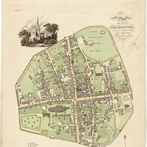
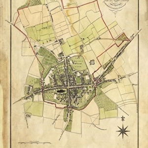
Fine Art Print : Map of Chichester within the City Walls, 1812


![]()
Fine Art Prints from West Sussex County Council
Map of Chichester within the City Walls, 1812
Plan of the city of Chichester from an actual survey taken April 1812 by George Loader, Surveyor
Printed Maps Collection
West Sussex Record Office Ref No: PM 154
West Sussex County Council Record Office contains a fascinating history of the county of West Sussex, England
Media ID 5978153
© reserved
Priory Park East Street North Street Pallant South Street Tower Street West Street
20"x16" (+3" Border) Fine Art Print
Discover the rich history of Chichester with our exquisite Fine Art Print of the city from 1812. This beautifully detailed map, taken from the West Sussex Record Office, showcases the layout of Chichester as it appeared over 200 years ago. Surveied by George Loader in April 1812, this rare and authentic print is a must-have for history enthusiasts and locals alike. Bring a piece of Chichester's past into your home and add character to any room with this stunning Fine Art Print from Media Storehouse.
20x16 image printed on 26x22 Fine Art Rag Paper with 3" (76mm) white border. Our Fine Art Prints are printed on 300gsm 100% acid free, PH neutral paper with archival properties. This printing method is used by museums and art collections to exhibit photographs and art reproductions.
Our fine art prints are high-quality prints made using a paper called Photo Rag. This 100% cotton rag fibre paper is known for its exceptional image sharpness, rich colors, and high level of detail, making it a popular choice for professional photographers and artists. Photo rag paper is our clear recommendation for a fine art paper print. If you can afford to spend more on a higher quality paper, then Photo Rag is our clear recommendation for a fine art paper print.
Estimated Image Size (if not cropped) is 36.9cm x 50.8cm (14.5" x 20")
Estimated Product Size is 55.9cm x 66cm (22" x 26")
These are individually made so all sizes are approximate
Artwork printed orientated as per the preview above, with portrait (vertical) orientation to match the source image.
FEATURES IN THESE COLLECTIONS
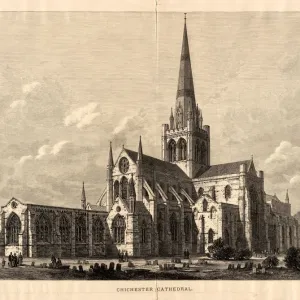
> Architecture
> Towers
> Cathedrals
> Europe
> United Kingdom
> England
> East Sussex
> Related Images
> Europe
> United Kingdom
> England
> Sussex
> Chichester
> Europe
> United Kingdom
> England
> Sussex
> Related Images
> Europe
> United Kingdom
> England
> Sussex
> South Street
> Europe
> United Kingdom
> England
> West Sussex
> Chichester
> Europe
> United Kingdom
> England
> West Sussex
> Related Images
> Historic
> Medieval architecture
> Towers and city walls
> City walls history
> Maps and Charts
> Related Images
> North America
> United States of America
> New York
> New York
> Sights
> Wall Street
> West Sussex County Council
> Urban
> West Sussex County Council
> West Sussex Record Office
> Printed Maps
EDITORS COMMENTS
This print showcases the intricate "Map of Chichester within the City Walls, 1812" meticulously crafted by George Loader, a skilled surveyor of his time. With its rich historical significance, this map offers an invaluable glimpse into the layout and architecture of Chichester during that era. The vibrant colors used to depict Close, South Street, West Street, Priory Park, East Street, North Street, Tower Street are truly striking. Each street is intricately detailed with precision and accuracy. The drawing of the cathedral at the heart of this map serves as a focal point - a testament to its prominence in Chichester's landscape. As we delve deeper into this remarkable piece of cartography from West Sussex Record Office's Printed Maps Collection (Ref No: PM 154), it becomes evident that every element has been thoughtfully included. From landmarks like Pallant House to lesser-known corners tucked away within city walls – no detail has been overlooked. It is important to note that this print is not associated with any commercial use but rather serves as an educational resource for those interested in exploring Chichester's past. Through studying maps such as these, we gain insight into how cities evolve over time and appreciate their unique heritage. In essence, this print encapsulates both artistry and historical documentation seamlessly merged together. It invites us on a journey through time while celebrating the beauty and charm of Chichester within its ancient city walls.
MADE IN AUSTRALIA
Safe Shipping with 30 Day Money Back Guarantee
FREE PERSONALISATION*
We are proud to offer a range of customisation features including Personalised Captions, Color Filters and Picture Zoom Tools
SECURE PAYMENTS
We happily accept a wide range of payment options so you can pay for the things you need in the way that is most convenient for you
* Options may vary by product and licensing agreement. Zoomed Pictures can be adjusted in the Cart.


![Chichester St. Peter the Great [Subdeanery] tithe map, 1846-1847](/sq/479/chichester-st-peter-great-subdeanery-tithe-10701869.jpg.webp)

![Royal Engineers bomb disposal team at work, [Mar 1941]](/sq/479/royal-engineers-bomb-disposal-team-work-8359434.jpg.webp)