Home > South America > Ecuador > Maps
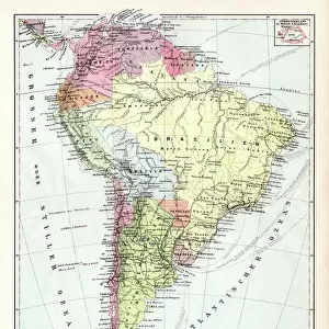
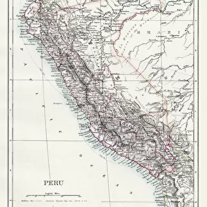
Map of Peru Ecuador Venezuela 1896

![]()
Wall Art and Photo Gifts from Fine Art Storehouse
Map of Peru Ecuador Venezuela 1896
Map of Peru Ecuador Venezuela
Unleash your creativity and transform your space into a visual masterpiece!
THEPALMER
Media ID 13613667
© Roberto A Sanchez
62990 Brazil Dictionary Earth Ecuador Globe Navigational Equipment Latin America Peru South America Venezuela Retro Styled
FEATURES IN THESE COLLECTIONS
> Fine Art Storehouse
> The Magical World of Illustration
> Palmer Illustrated Collection
> Fine Art Storehouse
> Map
> Historical Maps
> Maps and Charts
> Early Maps
> Maps and Charts
> World
> South America
> Brazil
> Maps
> South America
> Ecuador
> Maps
> South America
> Peru
> Maps
> South America
> Venezuela
> Maps
EDITORS COMMENTS
This print titled "Map of Peru Ecuador Venezuela 1896" takes us on a journey back in time to explore the intricate cartography of Latin America. With its retro-styled, antique appearance, this engraved image showcases the rich history and physical geography of these three South American countries. The meticulous craftsmanship evident in this engraving transports us to an era when maps were meticulously hand-drawn and engraved with utmost precision. The fine details captured in this piece allow us to appreciate the artistry involved in creating such a comprehensive representation of Earth's landscape. As we delve into the map, our eyes are drawn to the borders that define Peru, Ecuador, and Venezuela. Each country is depicted with distinct characteristics that reflect their unique topography and cultural heritage. Brazil also makes an appearance on this map, reminding us of its close proximity and influence within the region. The absence of people in this vertical composition allows us to focus solely on the beauty and complexity of these lands. It invites contemplation about how much has changed since 1896 while acknowledging that nature's grandeur remains timeless. "The Map of Peru Ecuador Venezuela 1896" by THEPALMER is not just a photograph; it is a visual portal connecting past explorations with modern-day appreciation for historical cartographic works. This stunning piece serves as both a reminder of our planet's diverse landscapes and an homage to those who dedicated their lives to mapping them accurately.
MADE IN AUSTRALIA
Safe Shipping with 30 Day Money Back Guarantee
FREE PERSONALISATION*
We are proud to offer a range of customisation features including Personalised Captions, Color Filters and Picture Zoom Tools
SECURE PAYMENTS
We happily accept a wide range of payment options so you can pay for the things you need in the way that is most convenient for you
* Options may vary by product and licensing agreement. Zoomed Pictures can be adjusted in the Cart.