Home > Maps and Charts > Early Maps
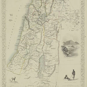
Antique map of the Key Islands

![]()
Wall Art and Photo Gifts from Fine Art Storehouse
Antique map of the Key Islands
Unleash your creativity and transform your space into a visual masterpiece!
Hemera Technologies
Media ID 13609439
© Getty Images
Archipelago Border Direction Document Geography Latitude Legend Location Longitude Place Positioning Scale
FEATURES IN THESE COLLECTIONS
> Fine Art Storehouse
> Map
> Historical Maps
> Maps and Charts
> Early Maps
EDITORS COMMENTS
This stunning antique map of the Key Islands takes us on a journey back in time, offering a glimpse into the rich history and geography of this archipelago. The print, meticulously crafted by Hemera Technologies, captures the essence of cartography from days gone by. The map is an archival treasure that showcases intricate engravings and precise detailing. Its vintage charm is evident through its faded colors and horizontal layout, evoking a sense of nostalgia for explorers and historians alike. With no people present in the image, it allows us to focus solely on the beauty and significance of this historical document. Captain Langes' expertise shines through as he expertly charts out each island's location with latitude and longitude coordinates. The border surrounding the map adds an elegant touch while also providing essential information such as scale and direction. As we study this piece further, we are drawn to its legend which unravels key elements about physical geography and positioning within these islands. It serves as a valuable resource for those interested in understanding how these lands were perceived centuries ago. Overall, this antique map offers not only visual pleasure but also serves as a window into our past. It reminds us of our fascination with exploration, discovery, and how maps have played an integral role in shaping our understanding of the world around us throughout history.
MADE IN AUSTRALIA
Safe Shipping with 30 Day Money Back Guarantee
FREE PERSONALISATION*
We are proud to offer a range of customisation features including Personalised Captions, Color Filters and Picture Zoom Tools
SECURE PAYMENTS
We happily accept a wide range of payment options so you can pay for the things you need in the way that is most convenient for you
* Options may vary by product and licensing agreement. Zoomed Pictures can be adjusted in the Cart.