Home > Oceania > New Zealand > Maps
Antique maps of New Zealand

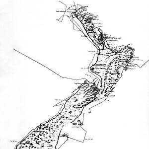
![]()
Wall Art and Photo Gifts from Fine Art Storehouse
Antique maps of New Zealand
Unleash your creativity and transform your space into a visual masterpiece!
Hemera Technologies
Media ID 13609403
© Getty Images
Border Chart Document Geographical Locations Geography Legend Locations Maps New Zealand Places Scene Bay Of Islands Captain Cook Captain James Cook Charts
FEATURES IN THESE COLLECTIONS
> Fine Art Storehouse
> Map
> Historical Maps
> Maps and Charts
> Early Maps
> Oceania
> New Zealand
> Maps
EDITORS COMMENTS
This print by Hemera Technologies showcases a collection of antique maps of New Zealand, offering a glimpse into the rich history and geographical wonders of this enchanting land. The intricate engravings and vibrant colors transport us back in time, unveiling the cartographic expertise of yesteryears. Each map tells its own story, revealing the exploration and discovery that unfolded across New Zealand's diverse landscapes. From the Bay of Islands to Tolaga Bay, these charts meticulously document key locations visited by renowned explorer Captain James Cook. As we delve into these archival treasures, we are reminded of the significant role they played in shaping our understanding of physical geography. The absence of people in this horizontal composition allows us to focus solely on the beauty and historical significance held within each map. The attention to detail is remarkable; every border, legend, and key adds depth to our comprehension of New Zealand's past. As we immerse ourselves in this scene captured through photography, it becomes evident that these antique maps are not mere documents but works of art themselves. They serve as a testament to human curiosity and perseverance in unraveling the mysteries hidden within uncharted territories. Whether you are an avid historian or simply captivated by New Zealand's allure, this stunning print invites you on a journey through time - where legends were born and boundaries were redrawn with ink on parchment.
MADE IN AUSTRALIA
Safe Shipping with 30 Day Money Back Guarantee
FREE PERSONALISATION*
We are proud to offer a range of customisation features including Personalised Captions, Color Filters and Picture Zoom Tools
SECURE PAYMENTS
We happily accept a wide range of payment options so you can pay for the things you need in the way that is most convenient for you
* Options may vary by product and licensing agreement. Zoomed Pictures can be adjusted in the Cart.