Home > North America > Canada > Maps
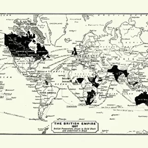
Map of British Canada 1900

![]()
Wall Art and Photo Gifts from Fine Art Storehouse
Map of British Canada 1900
Meyers hand-Atlas Leipzig und Wien Verlag des Bibliographischen Instituts 1900
Unleash your creativity and transform your space into a visual masterpiece!
THEPALMER
Media ID 18356601
FEATURES IN THESE COLLECTIONS
> Fine Art Storehouse
> Map
> Historical Maps
> Maps and Charts
> Early Maps
> North America
> Canada
> Maps
EDITORS COMMENTS
In this print titled "Map of British Canada 1900". THEPALMER takes us on a journey back in time to the turn of the century. The map, sourced from Meyers hand-Atlas Leipzig und Wien Verlag des Bibliographischen Instituts 1900, offers a fascinating glimpse into the vast and diverse landscape that constituted British Canada during this era. The intricate details and exquisite craftsmanship showcased in this artwork transport us to an age when cartography was both an art form and a scientific endeavor. Every contour, river, and settlement is meticulously depicted, revealing the immense scale of British Canada's territories at that time. As we explore this historical map, we are reminded of the significant role played by geography in shaping nations. From coast to coast, THEPALMER captures the sprawling provinces and territories that make up modern-day Canada today. It serves as a reminder of how borders have evolved over time while highlighting the enduring beauty of these lands. This print invites viewers to immerse themselves in history; it sparks curiosity about past explorations and settlements within these vast regions. Whether displayed in homes or educational institutions, this artwork not only adds aesthetic value but also serves as a visual gateway for learning about Canadian history. Through "Map of British Canada 1900". THEPALMER successfully preserves an important piece of our collective heritage while celebrating the artistry behind early cartography—a true testament to their passion for capturing moments frozen in time.
MADE IN AUSTRALIA
Safe Shipping with 30 Day Money Back Guarantee
FREE PERSONALISATION*
We are proud to offer a range of customisation features including Personalised Captions, Color Filters and Picture Zoom Tools
SECURE PAYMENTS
We happily accept a wide range of payment options so you can pay for the things you need in the way that is most convenient for you
* Options may vary by product and licensing agreement. Zoomed Pictures can be adjusted in the Cart.